
Nice.
Regards,
Ray

Nice.
Regards,
Ray
Very nice work Ray
Jeff, would you give the download page a better way of explaining how the meanwhile 3 oahu downloads go together?
Name them in proper hirachy or users will have a mess.

Jeff, would you give the download page a better way of explaining how the meanwhile 3 oahu downloads go together?
Name them in proper hirachy or users will have a mess.
It's pretty simple. Dave's scenery is a complete modeling of the PHNG airport (ICAO) or Kanehoe Bay US Marine Corps Base (as WIP). My upload is just a way to show PHNG in the Location menu of Aerofly with its runway and its lightning, but no modeling at all of runway, buildings, CT, static aircraft, hangars, etc. You can take some of my work and modify if you like the TSC file made by Dave, to change the lightning scheme of the runway, add some parking spots (that are also shown as you know in the Location menu in AFS2), and change the location of the main CT to its real one (this is useful to have a real view of any aircraft in AFS2 from the CT, in external view mode).
For both, you would want to have a geoconverted area of the Oahu island or part of it, covering the Kaneohe Bay area or, even better, the whole Oahu (to also cover PHNL Honolulu Intl). I've used FSET level 1 (with Virtual Earth enabled), giving me 6 area counts and a total area of 39 x 31 NM, which is not a big download/conversion process. Oahu island is not really a big area.
Hope this is helpful.
Cheers, Ed
name it e.g.
Hawaii - Hawaiian Islands, all Airports identifiers for Aerofly's GUI Nav Planner. V 1.0 by Rodeo. Does not include Airports Models or Scenery Objects. Requires -
Oahu, HI. - Island DEM and 1m pixel Sat Terrain map (Geoconverted). Does not include Airports Models or Scenery Objects.
PHNG - Airport identifier for Aerofly's GUI Nav Planner. V 1.0 by Ed. Requires -
PHNG - Airport 3D Model. Includes Area Sat Image, Runway, Buildings, Static Aircraft. V 1.0 by Dave. Requires -, WIP
These efforts regarding Oahu are a wonderful example of the power of individual contributors working together to produce a usable result but we shouldn't add to Jeff's workload - other than downloading a package occasionally. This is User Content and not official IPACS DLC and we have to thank IPACS for hosting the user content forums. I think Ed has summarized the order of things so far but Ray and others are already starting to add objects in Pearl Harbor. This will at some point result in more downloads - I will submit a newer version of the MCAS to deal with radar and tower updates and the other improvements done by others will also result in downloads. I appreciate this thread but I would like to have a summary of the current situation posted as a comment with the actual download - I will do so on mine. If Jeff finds the time to rename our downloads, that would be helpful but I don't want to count on it - it might start a trend of over-utilizing his time which needs to be spent on many other very important issues for FS2.
Dave W.
More on MCAS Kanehoe Bay (PHNG): for that might be interested, I would like to share my latest TSC file, updated to (in respect to the original one submitted by Dave W.):
1. Relocate the CT to its correct positioning (model). The smallest CT will not show (normally not in use in real life).
2. Add five parking spots in the Location menu in AFS2.
3. Change the lightning scheme for RWY04, that is the runway in use for takeoffs and landings.
4. Add two C-47 static models (see picture below) in parking positions.
5. Add three F-18 Blue Angels (see picture below) in parking positions.
Here is the corresponding TSC file:
<[file][][]
<[tmsimulator_scenery_place][][]
<[string8][type][airport]>
<[string8][sname][MCAS Kaneohe Bay]>
<[string8][lname][Marine Corps Air Station Kaneohe Bay]>
<[string8][icao][PHNG]>
<[string8][country][USA]>
<[string8][coordinate_system][lonlat]>
<[vector2_float64][position][-157.757549285889 21.4572751522064]>
<[float64][height][0]>
<[float64][size][5000]>
<[vector2_float64][tower_position][-157.7638784 21.4483556]>
<[float64][tower_height][55]>
<[bool][autoheight][false]>
<[string8][lights][]>
<[list_tmsimulator_runway][runways][]
<[tmsimulator_runway][element][0]
<[vector2_float64][endpoint1][-157.759033 21.457074]>
<[vector2_float64][endpoint2][-157.776868 21.443866]>
<[vector2_float64][threshold1][-157.759033 21.457074]>
<[vector2_float64][threshold2][-157.776868 21.443866]>
<[float64][width][60]>
<[string8][name1][22]>
<[string8][name2][04]>
<[string8][appltsys1][std]>
<[string8][appltsys2][malsf]>
<[string8][papi1][left]>
<[string8][papi2][left]>
<[string8][reil1][reil_uni]>
<[string8][reil2][reil_uni]>
>
>
<[list_tmsimulator_scenery_object][objects][]
<[tmsimulator_scenery_object][element][]
<[string8][type][ground]>
<[string8][geometry][ground]>
<[vector3_float64][position][-157.757549285889 21.4572751522064 3]>
<[float64][orientation][-90]>
>
<[tmsimulator_scenery_object][element][]
<[string8][type][object]>
<[string8][geometry][nas_kaneohe]>
<[vector3_float64][position][-157.757549285889 21.4572751522064 3]>
<[float64][orientation][-90]>
>
<[tmsimulator_scenery_object][element][]
<[string8][type][decal]>
<[string8][geometry][decal_rwy_04-22]>
<[vector3_float64][position][-157.757549285889 21.4572751522064 3]>
<[float64][orientation][-90]>
>
<[tmsimulator_scenery_object][element][]
<[string8][type][object]>
<[string8][geometry][nimitz_midspot]>
<[vector3_float64][position][-157.768843 21.440844 -0.2]>
<[float64][orientation][-30]>
>
<[tmsimulator_scenery_object][element][]
<[string8][type][object]>
<[string8][geometry][ground_fleet]>
<[vector3_float64][position][-157.713759 21.439553 1]>
<[float64][orientation][-90]>
>
<[tmsimulator_scenery_object][element][]
<[string8][type][object]>
<[string8][geometry][nimitz-total_ships]>
<[vector3_float64][position][-157.713759 21.439553 -7]>
<[float64][orientation][-90]>
>
<[tmsimulator_scenery_object][element][]
<[string8][type][decal]>
<[string8][geometry][nimitz-total_wakes]>
<[vector3_float64][position][-157.713759 21.439553 1]>
<[float64][orientation][-90]>
>
<[tmsimulator_scenery_object][element][]
<[string8][type][object]>
<[string8][geometry][tower]>
<[vector3_float64][position][-157.7638784 21.4483556 3]>
<[float64][orientation][-90]>
>
<[tmsimulator_scenery_object][element][]
<[string8][type][object]>
<[string8][geometry][radar]>
<[vector3_float64][position][-157.7739430 21.4444010 0]>
<[float64][orientation][-90]>
>
<[tmsimulator_scenery_object][element][]
<[string8][type][object]>
<[string8][geometry][ch-53]>
<[vector3_float64][position][-157.7672170 21.4408700 3]>
<[float64][orientation][-90]>
>
<[tmsimulator_scenery_object][element][]
<[string8][type][object]>
<[string8][geometry][f-18blueangel2]>
<[vector3_float64][position][-157.7676496 21.4480638 3]>
<[float64][orientation][345]>
>
<[tmsimulator_scenery_object][element][]
<[string8][type][object]>
<[string8][geometry][f-18blueangel2]>
<[vector3_float64][position][-157.7674431 21.4482061 3]>
<[float64][orientation][345]>
>
<[tmsimulator_scenery_object][element][]
<[string8][type][object]>
<[string8][geometry][f-18blueangel2]>
<[vector3_float64][position][-157.7672473 21.4483559 3]>
<[float64][orientation][345]>
>
<[tmsimulator_scenery_object][element][]
<[string8][type][object]>
<[string8][geometry][c-47]>
<[vector3_float64][position][-157.7668127 21.4486305 3]>
<[float64][orientation][345]>
>
<[tmsimulator_scenery_object][element][]
<[string8][type][object]>
<[string8][geometry][c-47]>
<[vector3_float64][position][-157.7665928 21.4487902 3]>
<[float64][orientation][345]>
>
>
<[list_tmsimulator_scenery_object_animated][objects_animated][]
>
<[list_tmsimulator_startposition][start_positions][]
>
<[list_tmsimulator_parking_position][parking_positions][]
<[tmsimulator_parking_position][element][0]
<[tmvector2d][position][-157.7722040 21.4451910]>
<[float64][heading][330.00]>
<[string8][name][Parking Position #1]>
>
<[tmsimulator_parking_position][element][1]
<[vector2_float64][position][-157.7685964 21.4462202]>
<[float64][heading][310]>
<[string8][name][Parking Position #2]>
>
<[tmsimulator_parking_position][element][2]
<[vector2_float64][position][-157.7691650 21.4431845]>
<[float64][heading][120]>
<[string8][name][Parking Position #3]>
>
<[tmsimulator_parking_position][element][3]
<[vector2_float64][position][-157.7775979 21.4467195]>
<[float64][heading][130]>
<[string8][name][Parking Position #4]>
>
<[tmsimulator_parking_position][element][4]
<[vector2_float64][position][-157.7662200 21.4490723]>
<[float64][heading][290]>
<[string8][name][Parking Position #5]>
>
>
<[list_tmsimulator_view_position][view_positions][]
>
>
>
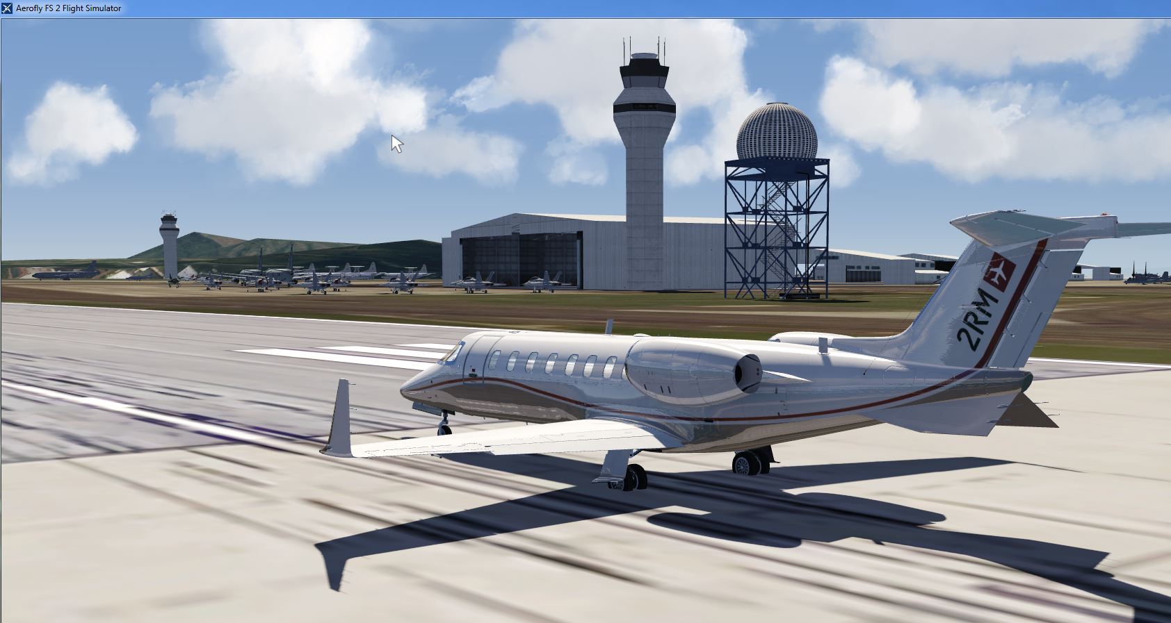
Here's the picture showing the addition of five static aircraft (C-47's and F-18's):
[Blocked Image: https://farm5.staticflickr.com/4337/36063707763_85594e914d_h.jpg]
Hope you like it!.
Cheers, Ed

These efforts regarding Oahu are a wonderful example of the power of individual contributors working together to produce a usable result but we shouldn't add to Jeff's workload - other than downloading a package occasionally. This is User Content and not official IPACS DLC and we have to thank IPACS for hosting the user content forums. I think Ed has summarized the order of things so far but Ray and others are already starting to add objects in Pearl Harbor. This will at some point result in more downloads - I will submit a newer version of the MCAS to deal with radar and tower updates and the other improvements done by others will also result in downloads. I appreciate this thread but I would like to have a summary of the current situation posted as a comment with the actual download - I will do so on mine. If Jeff finds the time to rename our downloads, that would be helpful but I don't want to count on it - it might start a trend of over-utilizing his time which needs to be spent on many other very important issues for FS2.
Dave W.
Probably what Jeff could do is to update the rules for posting User Created Uploads in the corresponding section, to address a better description of the creations and avoid confusion. This added description could be a text file indicating the content of the uploads in an explanatory way.
Just a suggestion now that we are anticipating a lot of user uploads.
Cheers, Ed
Here is the SBX ready, need to scale and export to see if Dave can import and position.
Here is the SBX ready, need to scale and export to see if Dave can import and position.
Wow. This is great. Ford Island is waiting g for it. Here are some of Dave's ships that I added to the area this morning.'\
Regards,
Ray
Michael,
You are moving so fast that it hard to believe. Should you wish to add even more spice to the cake. Just across the way from the SBX is the corner of Pearl City. To my untrained eye it appears that many or most of the buildings and docks are the same or very similar to the ones you are building for Ford Island. Maybe you can add a change order and also spruce up that corner with your magic.
There are probably a location or two that could use some of your cranes also.
I hope to have some sort of Navy ship docked at most every available dock one day.
Regards,
Ray
Yeah well, I'm going to be busy with other stuff in he next few weeks, but yeah I may do more stuff for HI. I have yet to fly it, tomorrow probably when I'll be onboard and get the terrain.
And I'm still far from finished with Ford Island (and the Superdome, and LA Harbor)
Here is another question for the specialists. When I created stuff for Ford Island, as you see it in your picture "sticks out" of flat water. Should I create a 3D island and raise it a few feet, then project texture onto it so that things don't stick out?
Wouldn't the terrain elevation map take care of that? (It doesn't look like it in your pict, but granted it's probably a few feet high anyway, so it's not that accurate)
 Display More
More on MCAS Kanehoe Bay (PHNG): for that might be interested, I would like to share my latest TSC file, updated to (in respect to the original one submitted by Dave W.):
1. Relocate the CT to its correct positioning (model). The smallest CT will not show (normally not in use in real life).
2. Add five parking spots in the Location menu in AFS2.
3. Change the lightning scheme for RWY04, that is the runway in use for takeoffs and landings.
4. Add two C-47 static models (see picture below) in parking positions.
5. Add three F-18 Blue Angels (see picture below) in parking positions.
. . . . the addition of five static aircraft (C-47's and F-18's)
Hope you like it!.
Cheers, Ed
Ed,
Looks good. Are you going to upload the C-47 and Blue Angel object models?
Regards,
Ray
Yes, in short the island needs to be elevated and a 3d island would be excellent.. Dave and Rodeo have experience with placing new scenery at the proper elevation, maybe they will join the conversation. I don't think anyone is expecting this complex scenery overnight, especially at this price. ![]()
Regards,
Ray
- it might start a trend of over-utilizing his time
Dave W.
the opposite is the case, Dave.
Clear tagging rules prevent chaos, so i had to jump in and save Jeff's life.
If all user scenery uploads need to go via Jeff's Desk, no wonder he is busy.
It seems aerofly is not ready for user content flow.
My request for was directed to the users by the way, so they are aware of proper content naming.
agree to Ed's thread #67 .
The USGS has 1 foot imagery of this area but I don't have the time nor patience to build that many tfw files. They don't have any 1m stuff for here. duh. Dave said in another thread that it is possible to use the GIMP clone feature to cover up most of the clouds with favorable results.
Regards,
Ray
no worries Ray, leave the USGS source for all users, someone will pick the job.
so you can focus on the airport models.
Two Control Towers.
Regards,
Ray
Well. that certain answers the question about what the original control tower looks like. It will probably take someone like Michael to replicate this tower if we wish to use it in our scenery. Otherwise,. maybe we can just cut off the top of a real similar tower and put it on the corner of Hangar Five.
Thanks for the close up photo Almdudler.
The problem when you have two clocks with different time, you never know for sure what's the time. Check out the Elevation 17 feet in the previous picute and and 24 feet on this one.. duh.
Regards,
Ray
Ed,
Looks good. Are you going to upload the C-47 and Blue Angel object models?
Regards,
Ray
Ray, these models are in the IPACS download section. Look for Dave's "Generic Airport Objects Library" and follow the instructions after unzipping it (as I remember there's a text file). You'll find hundreds of airport objects and aircraft from GA, Business to Military and Commercial, apart from buildings, hangars and large CT's, but not smaller ones like the old at Kaneohe MCAS ![]() .
.
Cheers, Ed
Ray, these models are in the IPACS download section. Look for Dave's "Generic Airport Objects Library" and follow the instructions after unzipping it (as I remember there's a text file). You'll find hundreds of airport objects and aircraft from GA, Business to Military and Commercial, apart from buildings, hangars and large CT's, but not smaller ones like the old at Kaneohe MCAS
.
Cheers, Ed
Yep. Thanks.
Ray
I came across a super high def photo showing many of the buildings on the Marine Base at Kaneohe Bay. This is an aerial view from over the marina and is seldom seen on the web.
I also found a close up of the new control tower and the nearby building in case anyone wishes to add these objects to our growing scenery package.
If anyone is interested in making some additional custom buildings or just adding something similar let me know and I will send you the full sized image.
Regards,
Ray