
Could be, did you look to see?
Ray

Could be, did you look to see?
Ray
For me it stops at 0.010%
Any ideas?
same issue here ![]() geoconverter does not work. I kept it running all the night and nothing completed. seems similar to Pokredde who posted above.
geoconverter does not work. I kept it running all the night and nothing completed. seems similar to Pokredde who posted above.
thanks.
Hello,
When I try to launch aeroscenery I have a strange message:
La référence d'objet n'est pas définie à une instance d'un objet.
à Dapper.SqlMapper.<QueryImpl>d__138`1.MoveNext()
à System.Collections.Generic.List`1..ctor(IEnumerable`1 collection)
à System.Linq.Enumerable.ToList[TSource](IEnumerable`1 source)
à Dapper.SqlMapper.Query[T](IDbConnection cnn, String sql, Object param, IDbTransaction transaction, Boolean buffered, Nullable`1 commandTimeout, Nullable`1 commandType)
à AeroScenery.Data.SqlLiteDataRepository.UpgradeSchema()
à AeroScenery.AeroSceneryManager.Initialize()
à AeroScenery.Program.Main()
What should I do ?
Thanks in advance

When I try to launch aeroscenery I have a strange message:
Is this a new installation or an upgrade?
If you have no existing data to lose you could just delete the AeroScenery database and let it create a new one.
(By default it's in the {Windows Documents}\AeroScenery\database folder).
Thanks a lot, It works perfectly now !

For me it stops at 0.010%
Any ideas?

same issue here
geoconverter does not work. I kept it running all the night and nothing completed. seems similar to Pokredde who posted above.
thanks.
GeoConvert is a disaster of an application frankly and there's unfortunately not much I can do about that. I wish there were. Seems like Aerofly SDK releases have stood still in the time I've been away.
It does work for some people on some machines is all I can say.
It's particularly sensitive to having the GeoConvert window moved around, minimized, maximized etc.
Let AeroScenery run GeoConvert and leave your PC alone if you're experiencing GeoConvert issues. I let it run overnight if possible.
Welcome back Nick.
Still wishing everyday for the USGS version of AeroScenery.
Regards,
Ray

Welcome back Nick.
Still wishing everyday for the USGS version of AeroScenery.
Regards,
Ray
Implementing ArcGIS will provide that, see..
can anyone give me a hint. I installed aeroscenery but get a startup error upon launch. "error reading aeroscenery settings.xml"
What do you mean by installed?
Did you just decompress the last version 1.1.3? Then it will probably not work.
First install the older version with the appropriate "msi" installer version 1.0.1 and then overwrite the installed version with the new unpacked version 1.1.3.
After the installation you should have a new directory in your user directory "<user>\Documents\AeroScenery\" containing the setting.xml and the subfolders "database" and "working". Do you have them and does it work now?
Back in business - will get the new Swiss textures now in ZL17
Glad that it works for you now. Would be great if you could share this new texture.
Do i need the Aerofly SDK to use AeroScenery, would like to build tiles for my country for Aerofly FS 4 ?

Do i need the Aerofly SDK to use AeroScenery, would like to build tiles for my country for Aerofly FS 4 ?
You can use the content converter from AFS2 SDK. Work perfect
Display MoreI'm opening a new thread for AeroScenery releases as the last one has started to get unwieldy.
After some beta testing by the good people on here I'm pleased to announce that AeroScenery 1.0.1 is now available.
Download here : https://github.com/nickhod/aerosc…AeroScenery.msi
New Features In 1.0.1
On-the-fly Image Processing
You can now have AeroScenery adjust the sharpness, brightness, contrast etc of the image tiles that you're about to convert
Sequential GeoConvert Execution
AeroScenery now detects when GeoConvert is done, kills the GeoConvert process and starts the next one.
This means that multiple GeoConvert instances wont be started at once.
Install Scenery
Install scenery to your Aerofly My Documents folder or configured external user folder from with AeroScenery. No more copy and paste
Fast Delete
Clean up downloaded tiles with a super-fast, low level grid square folder cleanup feature
Grid Square Sizes 9 - 14
Select any grid square size from 9 - 14. Choose what fits your project best
Fixed Grid Square Hex Names
Previous version got the hex names of grid squares wrong. They are now correct in this release.
Xml File Based Config
No longer registry based.
Configurable Orhotphoto Source Urls
It's now possible to change the url templates for orthophoto tile download from the config, if a certain server is down or faster for you.
Can the maps made with it be imported into Aerofly Fs 2 for use?
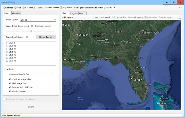
Yes, by entering your AFS2 User folder path into the settings:
and select a generated tile in the map, click Install Scenery:
Do this for each tile you generated.
Yes, by entering your AFS2 User folder path into the settings:

and select a generated tile in the map, click Install Scenery:
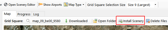
Do this for each tile you generated.
What are these two folders?
How do I choose?