Posts by crispy136

    I get red error messages for each of the "CreateAF2Building" lines saying that 4 arguments are required.

    HI Ian, You may be using a different version of ScenProc. I'm using a ScenProc build dated 16/10/18. You can find this information right at the top of the screen after the version number. I had a look through the changelogs for Scenproc and can't see any changes to CreateAFSBuilding code since 16/10/18. Try updating and see if the problem goes away.

    These 2 lines control the placement of the houses on each side of the street.

    PlacePointsAlongLine|FTYPE="LINE" And highway="residential"|SINGLE|16;18|20;21|0|String;type|build1|hdg

    PlacePointsAlongLine|FTYPE="LINE" And highway="residential"|SINGLE|16;18|-20;-21|0|String;type|build1|hdg

    The value |16;18| sets the distance between houses to 16 to 18 metres. I was originally using 20;25 but found it was too sparse for cities, so give that go first then increase it until you get the desired density.

    The value |20;21| and |-20;-21| sets the distance of the houses from the centre line of the street to 20 to 21 metres. Increase this for wider footpaths. There are a pair of lines for each street with one set being negative. You need to change both together or you well get houses closer to the street on one side.

    Even with increased house spacing it look like you will need an include, to get rid of the houses in the background. Unfortunately OSM seems to consider any street with a house on it as residential, even though there might be just a couple.

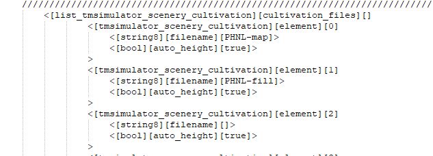
    Have released my housing fill template to create houses where there are no housing footprints in OSM. The script is run separately from my other template which will continue to be developed. This means you will need to insert references to the 2 TOC files into your airport TSC file as indicated in the Honolulu (PHNL) TSC below.

    The template uses residential roads to decide where to place the houses. This has some limitations. For instance it is not possible to have it align the houses with the photo imagery of the houses, and you will find some small areas with no houses. Houses will not appear on other road types as these proved difficult to use successfully. The script is also limited to only houses, no larger buildings are generated .

    This template is designed so it won't create overlaps of buildings, or plants generated by my other template and has no impact on street lighting. The template is not 100% perfect so you may find the odd house where it shouldn't be, but houses are filtered out of most areas where they shouldn't be.

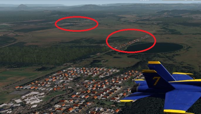
    As the template uses residential roads, and these sometimes appear in rural areas in OSM, I found you can often get lines of houses on a single street in the middle of a rural area. To combat this problem, I create an include polygon using Google Earth to define the urban areas of my cities and towns. You can run the script without an include but you will need to comment out a few lines of the template. The lines to comment out are documented in the script itself. The script makes no allowances for exclude polygons, as it is a lot easier to define an urban area to include than it is to define a rural area surrounding an urban area to exclude.

    You can have multiple polygons in your google earth include.kml file. And I also create the polygons for my whole city area, then use the same include for each level 10 area I am generating cultivation for, so there is no need to try and align the size of your include with the size of the OSM data area. When creating your include polygons in Google Earth it is best to set opacity to 40% so you can see the underlying urban areas as you create the polygon. This appears on the "style color" tab on the popup window that appears when creating or editing Google Earth polygons.

    Its a pretty quick process once you get the hang of it. Anyone wanting to know how to create Google Earth Polygons should look at the original "learning cultivation" video. The same method is used to create include polygons required here, as detailed in the video to create exclude polygons. https://www.aerofly.com/dokuwiki/doku.php/sdk:scenerydev4. Larger city areas may not require the use of an include polygon.

    Unlike my original template which is always attached to the first post in this thread, this one is attached to this post. Just rename it as .spc, create your include polygon (or comment out the noted lines) and you're good to go. As with my other template this one also works best when you are using a level 10 sized area from OSM. Run time was 5 minutes for my level 10 sized area in Honolulu and 40 minutes for my level 10 area for New Orleans which is mostly houses. The resulting TOC files are not large but it does require a lot of calculations to create them. My other similar sized test areas took 5 to 10 minutes. CPU usage peaks at 90%+ for some parts of the script but varies from step to step to as low as 15%.

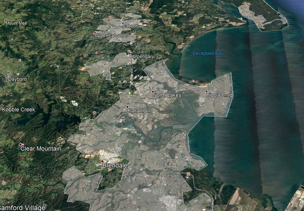
    Example of a Google Earth include polygon. Not separate polygons for the satellite towns to the north and north east of the main city area.

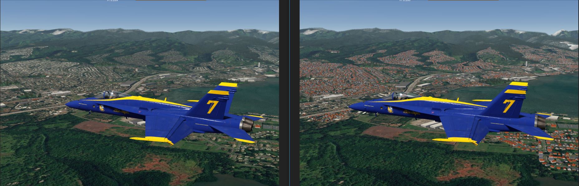
    Example of houses created for Honolulu, before on the left and after on the right.

    Example of what can happen when you don't use an include polygon to define your urban areas.

    Sorry, its not ready yet. Have fine tuned the performance a little further since my last post, but still a few things to resolve. At present it is a separate template you have to run, creating a second toc file to be added to your airport tsc. It runs on the same map.osm file as the OSM sourced building, plant & light data though. Will probably stay as a separate template as I think it is going to be too difficult to integrate it into the existing template. My initial test of a very small area took 40 minutes, so I had to fine tune the template for better performance in order for it to run for a level 10 sized area. While the level 10 sized area in Australia shown in the screen shots above ran fine and completed in about 10 minutes, New Orleans ran for 2 hours before I gave up and cancelled the job. After the fine tuning the template a little more, the Australian test area running time dropped to 5 minutes and New Orleans completed in 10 minutes. CPU usage originally peaked at 15% in earlier tests but now peaks at 70% so scenProc is working harder. I'll also see if I can apply these performance enhancements to the main template.

    In the meantime here are some screen shots of testing done in New Orleans. Once again the left shot is OSM building data only, while the right has the generated buildings from the new template. A few of the original buildings may look like they are missing or different, but this is not the case. FS2 randomly assigns building colours at startup so a building with a white roof may be less visible with gray roof the next time you load FS2.

    Looking towards Louis Armstrong airport where there is little OSM building data.


    And here a little further to the east and integrated into an area that already had a lot of OSM building data. Notice OSM buildings on the right are not compromised, even though they were included in the area the scenProc script was generating.

    Have been working on a project to add houses where no building footprints exist in OSM data. It is still work in progress but I have managed to add housing using OSM data not related to buildings. The left image shows the cultivation using just OSM data, while the right image shows buildings added with the new housing process. The limitation is that the new houses don't occupy the footprint of the houses in the textures, but you won't find them in the middle of roads, rivers, plant areas or any area with existing OSM recorded buildings. Only tested in Australia so far and not sure of the impact of denser areas.

    Additional housing added without impacting existing building, plants or lights.

    Added housing follows street layout

    Houses everywhere now.

    Had a quick look at other refineries in the USA and many do record the storage tank attribute in OSM, so hopefully you won't need to use an exclude everywhere.

    I have tested the change in the template and confirm that it does work where this attribute is recorded in the OSM data. I will include it in the next template update.

    I added it to "Filter Buildings" section as "AddAttributeIfInside|building="*"|man_made="storage_tank"|String;skip|yes" rather changing the "CreateAF2Building|building="yes"" lines. This way it works for all building categories rather than just those classified as "yes". This should cater for some inconsistencies in OSM data.

    I tried the "storage tanks" code and it failed. It actually added even more houses in the "storage tanks" area

    Hi Ray. I hadn't had a look at the area before as I was just responding to the code supplied by Ken. When I had a look at your area unfortunately none of the storage tanks I looked at have the attribute "man_made" = "storage_tank". As a result the code supplied by Ken will not be effective here.

    When looking at your problem I found I have a similar problem for an oil refinery near my local airport. Luckily these tanks do have the "man_made" = "storage_tank" attribute in the OSM source data, so I'll include the fix in my next template release. At least this will remove tanks in some areas.

    All your tanks sit in an industrial area, so you could use that area to exclude any buildings (ie the tanks) in much the same way my template excludes airport buildings automatically. But unfortunately that would also exclude any buildings in the same area as well. It would also prevent buildings appearing in other industrial areas, which is probably not desirable.

    I think your best option is to manually create an exclude for the area with the tanks.

    You are limited to what detail is recorded in OSM and sometimes really odd things are classified as buildings. For instance static historical ships, like the USS Missouri in Hawaii, are classified as buildings in OSM. Luckily they have enough other detail in OSM that allows me to exclude them easily.

    CreateAF2Building|building="yes" And man_made<>"storage_tank" And FAREARAT>0.7 And FAREA >=700 And FAREA <6000|2|1|flat|commercial|0

    CreateAF2Building|building="yes" And man_made<>"storage_tank" And FAREARAT>0.7 And FAREA >=700 And FAREA >=6000|4|1|flat|commercial|0

    Don't think that will work as scenProc only imports the following fields for any object even when you nominate everything "*"..

    aeroway,amenity,boundary,building,craft,geological,historic,landuse,leisure,military,natural,office,place,shop,sport,tourism

    You would need to add "man_made" to osmconf.ini in order to use it as a restriction.

    Also I haven't had any luck using "<>", so I think you would need to use "NOT" as indicated below.

    CreateAF2Building|building="yes" And NOT man_made="storage_tank" And FAREARAT>0.7 And FAREA >=700 And FAREA <6000|2|1|flat|commercial|0

    CreateAF2Building|building="yes" And NOT man_made="storage_tank" And FAREARAT>0.7 And FAREA >=700 And FAREA >=6000|4|1|flat|commercial|0

    Have updated the template with the following enhancements:-

    . Added feature to filter buildings from airport areas automatically. It is no longer necessary to create an exclude for airport areas. This works in most parts of the world.
    . Added feature to remove trees from playing fields. In Australia UK and the USA it is common to have playing fields located in areas designated in OSM as parks. Without this update you end up with trees appearing in playing fields such as cricket pitches, hockey fields, baseball diamonds etc. European countries do not seem to categorise areas with playing fields as parks in OSM, so is not a problem for them. Note - this feature has a slight time penalty of about 2 minutes on level 10 my test area.
    . Corrected comments about the size splitting of houses.
    . Added new plant area for scrub (Australia specific I think)
    . Added new street lighting with traffic lights created by Kenventions.

    The following picture shows the region of Titusville exported from OSM and opened in JOSM.

    Thanks for the information Thomas. I'll definitely have a look at this. I can see that this would allow you to easily add missing objects. For me this would perhaps be most suitable to add missing landmarks near airports. Personally I would want to avoid manually adding a lot of objects to the OSM data, just from a time and effort perspective. My preference is to create sufficient detail to enhance the realism of the FS2 with the least possible effort. After all you're only going to fly over it briefly.

    East Center Florida where it land juts out to the East is Cape Canaveral/Kennedy Space Center. That is the area I am working in today. -80 w 29 deg will get you in the neighborhood.

    Hi Ray, Looking at the area in OSM the problem is that there is very little data recorded for buildings, so scenProc can't create much. Unless you use another source your cultivation is not going to get any better. OSM is the only source I am aware of but I know other users have produced more detailed areas where OSM has a lot less detail.

    The gray squares inside the red circles represent buildings in Titusville. Notice there are on very few gray squares. It you use the select tool and click on a building you can see what values are available for that building. Most buildings I clicked on contained the same values as this one, which was virtually nothing. Trees are not a problem as green areas seem to be well documented in this area.

    Compare this with the area in the region I live. It is filled with buildings! The city centre shown in green has nearly every building recorded. The urban areas in red in the red circle are also well detailed, as is the commercial and residential areas around it. Also the buildings themselves are well documented with the type of buildings and the number of levels. This level of detail gives good results with cultivation. Unfortunately this level of detail is not sustained through all of the suburban and industrial areas of my region. Some are like this, some a bit sparser, and some with nothing. But like your area, green areas are well documented in most places.

    98% of the houses are not cultivated.

    I did see comments in other threads that too much cultivation can result in stuff disappearing. Perhaps the area you are selecting in OSM is too large, level 10 is the recommended size. Also are there any houses in OSM for the missing areas? I have found that whole suburbs are just missing in my home city, while in other areas every house is recorded. ScenProc is limited to what is recorded in OSM. Send me details of the OSM area where there is a problem with missing houses and I'll look at the source data to see if something needs tweaking. You can also try using one of the older templates (ver4) that uses the building length to cultivate buildings. I changed it to building area in ver5. Don't forget this will disable any features introduced in ver5 and is just for troubleshooting. The attached file is ver4 but with the SplitGRid and MergeGrid enhancements included.

    Did a little case study myself as I have learned to create Fscloudport airports, photo textures, cultivation and now mesh for Australia. The area is an Island resort in the Whitsunday Islands in north east Australia. Just did a small level 11 sized area.

    Standard FS2 - no development by Ipacs other than low res textures and mesh.

    With basic Fscloudport airport runway

    With detailed Fscloudport airport

    With photo textures - at last something that starts to look real, but the harbour and the shoreline above it are heading uphill

    With mesh - harbour and shoreline above now flat. Compare the hills below with the screen shot above. Note - the island on the far right horizon is outside the mesh area.

    With cultivation - the icing on the cake. Not a lot of detail available in OSM for this area, but enough to add realism with little effort.