

Yes,
There is a special function Burn Colors into Textures .
Rodeo
Awesome, that should be the final hurdle for me.
going to be lots of Ground Support Equip in my scenery now ![]()
Yes,
There is a special function Burn Colors into Textures .
Rodeo
Awesome, that should be the final hurdle for me.
going to be lots of Ground Support Equip in my scenery now ![]()
Display MoreMustang60348,
yes, this would be possible as well, but not yet in the next few days.
As I have written above, I do several more steps before exporting to .ac:
Rename texture files, resize texture files to a power of 2, convert sketchup color into texture file, convert texture files to BMP.
Very quick tutorial writeup:
Use the icon 'Material Editor' within MCX, go to textures in the bottom line, run the options in the top line and save textures as BMP.
Rodeo
Is there an easy way to 'convert' sketchup colours into textures. I tried your suggestions at lunch time and so far so good except for that one.
 Display More
"I am even exploring a MACRO method. ie.Download a macro recording program, record the actions in FSET and Geoconvert Helper and include the resulting macro with the distribution. Now all the user has to do is download the macro recorder program and run my macro."
How about a zip download that contains FSET preconfigured with an INI that holds the co-ords, as well as the geoconvert helper and ideally a copy of geoconvert which I think runs standalone, so the whole lot could go in a separate folder even if someone already has geoconvert. This would require:
1) Approval from FSET guy. Is he still around? Would he really mind - its all shareware anyway?
2) IPACS approval to bundle geoconvert
3) As above for the helper
4) Ideally the ability to run the helper with commandline or batch file... in fact can FSET run with commandline options, enabling a BAT file for the whole lot?
Definitely some things to explore
Please understand that it this point in time you are not allowed to share the aerial images derived from the geoconvert method. You can share the airport and airport models though.
Yup. I know. I am also looking at a method to distribute the settings for FSET and Geoconvert Helper along with the 'airport' so that the user can simply plugin the settings into FSET and Geoconverter helper and make the textures necessary for the scenery.
I am even exploring a MACRO method. ie.Download a macro recording program, record the actions in FSET and Geoconvert Helper and include the resulting macro with the distribution. Now all the user has to do is download the macro recorder program and run my macro.
Update: I have 12 out of 20 buildings completed.
Moving at a good pace, having a long weekend with my wife working helps ![]()
Display MoreMustang60348,
yes, this would be possible as well, but not yet in the next few days.
As I have written above, I do several more steps before exporting to .ac:
Rename texture files, resize texture files to a power of 2, convert sketchup color into texture file, convert texture files to BMP.
Very quick tutorial writeup:
Use the icon 'Material Editor' within MCX, go to textures in the bottom line, run the options in the top line and save textures as BMP.
Rodeo
Thanks, will have a look at that when I get home.
Display MoreHi,
within ModelConverterX several operations are necessary for sketchup files:
Rename texture files, resize texture files to a power of 2, convert sketchup color into texture file, convert texture files to BMP.
These steps can be done semi automatically. Make sure to use version 1.4, not the 'stable' but outdated version 1.3.
Within AC3D more operations are required: Set faces to single sided surfaces and cut the whole sketchup project into separate buildings.
A manual remapping is not required, only in some special cases.
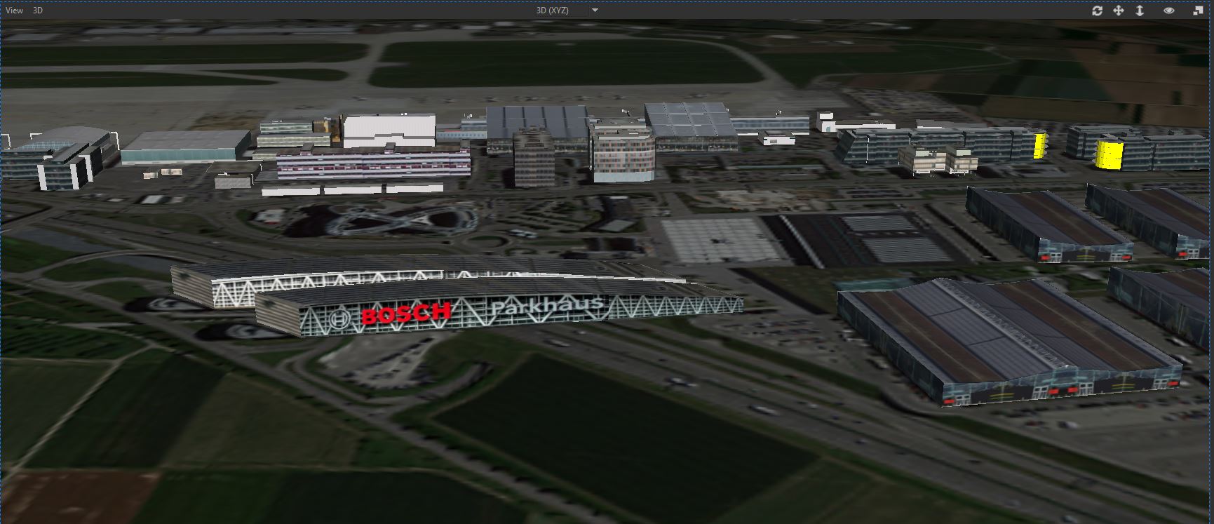
In the meantime I created the BOSCH parking decks and the Stuttgart fair halls by drawing them in AC3D and adding foto textures to them.
Rodeo
Would it be possible to do a quick 'tutorial' writeup for the conversion of Sketchup models to Aerofly using ModelConverterX. I have done it and the geometry comes out great BUT the textures/colours are missing.
Here is what I am doing
I open the model in Sketchup, export it as .dae (I think) file, import into MCx , but the textures don't show up.
I finally got a ton of reference photos for 14 wing Greenwood CYZX
As a result I am going to make all custom buildings myself and thus I will be able to release it to the public.
I am currently using other people's work for the buildings and so far have been unable to get permission to use them, alas I have decided to do it myself.
It will take some time but I will get there.
All the runways, taxiways, and markings are already done and once I am done the buildings, I can release it.
They already are released... (Scenery SDK???)
Excellent. So they use the same tools we have. That is good news.
Well when comparing different sims you are comparing different methods. FSX and X-Plane have world wide airports but they are not hand made or at least for the majority of airports not much time was invested. They aim for quantity and world coverage, we have a different strategy: We spend more time on each airport so that each airport is representative of it the real world airport. They do have taxi lines, parked aircraft and cars, some even have animated people, all terminals are hand made and look quite realistic, we have cities that look like the real ones - so we aim for quality for large areas but not the entire world. We might get there at some point, we may also generate the remaining airports in the future... Mathematically I think you sort of have to multiply quantity and quality to compare the sims.
So the difference, really, comes down to: accuracy and realism in large areas (you can fly for hours in a straight line in the current region, even with the F18) or all airports around the globe and land class or autogen in not so good quality (not looking realistic or lacking detail). We currently can't give you every airport around the world because so far we hand crafted every airport and that takes at least a couple of hours for even tiny airports... Large airports like Denver, Las Vegas, Los Angeles, San Francisco and Zurich take months to make! But that is the only way to get to such high quality that you only get from the other sims when you purchase expensive add ons. (I know X-Plane now also has custom made airports, lots of them made by the user fan base, which is a good idea to cover ground)
So far in the USA only New York did cost any money at all, so why are you assuming that you're going to need hundreds of micro transactions to complete the entire USA? (Firstly there are only 50 states, secondly we already have 5 states for free and NYC for a quite small price compared to other add-ons for other sims in that region and we have Chicago Meigs field by OrbX)
- Where does that leave us?
We're going to continue making more scenery and will look into ways to even generate parts of it to add more buildings and other things like street lights, etc. We could just generate every airport around the globe but then you wouldn't have any ground textures around it and that just looks odd. Plus we'd have to add a way to remove them if any add-on company develops that airport.
Add-On developers like Orbx now have the tools they need to create their own scenery in Aerofly and I think we will see many new scenery created externally.
Aerofly FS 1 wasn't abandoned, the developers just went quiet to bring you Aerofly FS 2. The Aerofly engine was subject to some serious re-design to offer support for world wide scenery, we added navigation databases for the entire world and did a lot of other things under the hood - not to mention new aircraft, a new starting area which is much much larger and had to be made.
Regarding ORBX having the tools to develop sceneries. Will those tools be released to the general public OR did Orbx develop those tools in house.
 Display More
IF Geo convert is going to remain an unpolished extremely difficult to learn and actually use dos-level-dev tool, and customers cannot legally fileshare sceneries online in an open format like FSX or prepar 3d does; then is ipacs going to release real global scenery files later on instead of all these little sections of parts of states etc?
I am just trying to see the endgame, release goals is all.
Too much vague and guessing is going on. It seems nobody has an honestly clear picture of what is being offered and what we can look forward to. No disrespect intended in any way. But everyone I ask is in the dark as to whether you will ever actually end up ever doing in AF2 what has been done in the other 2 big player sims all decade.
I love how AF2 looks and runs. Will it or will it not become what the others are please?
And I direct this question to any and all who can answer. I am searching for something fantastic to get excited for in the future of this sim in the area of actually taking off from one national location and fly cross country or intercontinental to another airport; over real textured scenery.
Sorry to be so specific, just searching for that elusive concrete answer is all.
We also can't really judge how it runs right now because there is so much missing that will effect the FPS when it comes. ATC, Traffic, Real Weather etc. It runs silky smooth right now because in a lot of ways, Aerofly is simply a 'simple' flightsim and graphics engine.
 Display More
I keep thinking there should be a very simple solution to the freeware sharing of user generated data using FSET and GeoConverter. Something along the lines of the one building the scenery does not provide 100% of the working files, more like 99.98% but retains a missing link that will keep the scenery from running properly.
The user that downloads the user generated files would have to provide the missing link by generating the the missing pieces. That way it would be more like a homebuilt airplane and 100% legit in the eyes of the current unwilling ones.
The tmc file data could be provided and the necessary co-ordinates but the end user would have to perform this final step for true ownership of the working product and, of course agree not to share the product with anyone else.
Or something simillar where the shared scenery project has to actually be a “shared” project.
Regards,
Ray
Did you get my latest email from a few days ago about my encounter with one of the people I contacted about the models and his reaction.
I look forward to the Florida Keys upload then. That would be a treat to fly around. Will be checking back here for it, thank you for your response Dean. Much appreciated for the information.
The Geoconvert tool has been out for much of the year right? Wondering where is the user created content after all this time? The add on ships and airports on the download page you mentioned look fun, but that's not really a scenery like the tool was supposed to help customers create and share, right? I am puzzled that nobody has tackled learning it after all these months and posted up a bunch of downloads? Maybe I am out of the loop?It's good to see a few people posting they are trying to learn it. And I see all the threads on the bugs and crashes. I read in the forums where some are posting their plans for it. But after all these months still nothing? I have looked at the tutorials and admit I simply do not have that much free time or patience to tackle something like that myself. Like they said on the Steam forum, it totally isn't for everyone. I hope I am coming over properly, I only mean to ask if I have missed something? I'd hate myself if there really were lots of user created areas of scenery somewhere and i just missed it.
I have created CYZX, CYHZ, CYYT, CYQX, CYQM BUT , I have no idea what the legalities are of using Geoconvert with Google Earth data. SO I have to keep them to myself. There is one person on the forums here I have shared a couple of these with to help me test and he has been invaluable but I can't share publically because of the uncertainty of all this.
I asked earlier how IPACS does it and got a rather vague answer that they don't use Goggle Maps but for some reason they never expanded on what they do use.
You can get very high resolution scenery using our geoconvert tool. We have tested scenery at 0.25m and it looks and runs great in Aerofly FS2!
Do you guys use Google Earth VR or Google Earth as the source for you scenery OR do you have another source.
Please just understand that the geoconvert helper is an application made by a user and not by IPACS therefore if something goes wrong with your process you should always try the process manually before stating that there are problems.
For sure.
I might just have to learn to do it manually since I have only ever done it with the app.
No,
it's just your personal preference.
Thanks.
Are there any advantages to using the geoconvert , 'manually' vs the geoconvert helper tool.
I put the TOC files in the following location and they work fine. I have done 6 airports so far
\Documents\Aerofly FS 2\scenery\places\"AIRPORT NAME"
Change AIRPORT NAME to the name of the airport you are building
Where did you put the TOC files. i.e. which directory.
I think we documented that in the scenery SDK actually. I'm not sure where that part is in the wiki but I do remember writing it.
You basically make a 3D model of the runway and don't use autoheight.
Thanks , found it.