
All text files can have comments starting with //
In your case you probably made a small mistake, maybe post a small snippet here to lets us check it.
I just re-tried it. Worked this time.
All text files can have comments starting with //
In your case you probably made a small mistake, maybe post a small snippet here to lets us check it.
I just re-tried it. Worked this time.
Created this airport to learn various techniques for getting 'stuff' into Aerofly.
Runways
Buildings (imported)
A/C (built in)
Decals (Runway Markings and Taxiway Markings)
OpenStreet Map Buildings and Trees and Lights
FSTiles data for the ground.
 Display More
Hi,
I use the first line for a comment, that's all.
<[file][][Aspen]
You may use the numbers to mark certain objects.
<[light][element][1]
Don't know more possibilities in the moment.
Rodeo
Thanks

When I run the sim from Oculus Home in 'other vr' mode, the above issue is improved but I seem to get a slightly different issue with little glitchy movements on different items around the cockpit.
I meant RUN it native from Steam.
Well we implemented something similar already, not in the HUD though.
Left of the HUD you see a couple of arrows and a circle that light up when the gear is down. They show you the same thing, to fast, to slow and on profile.
Thank you for the suggestion though
That's the AOA indexer and while similar the E Bracket would be much more useful.
Why run it with Steam VR, why not run it Native.
Would love to see the E-Bracket implemented: The E-Bracket is a hud indication that shows perfect ON SPEED indication for the current configuration: It is shown just left of center on the HUD and looks like an E , it moves UP and Down to show if you are ON SPEED, Above Speed or Below Speed. It is only shown when the gear is down and locked. In essence it shows where you are in relation to perfect AOA.
As per Title, is there a way to put comments in the TOC file. I have tried double slashes like TSC but that doesn't work.
I have an Nvidia Card 1060 , I use Geforce Experience to do it.

Next question. Do I start GeoHelper first, then start FSET? Nothing was copied over to GeoHelper on my first try. Snap to FS2 level 9 grid is greyed out.
Should Create raw images have a checkmark in the box? Should Create mark images have a checkmark in the box?
Regards,
Ray
1) I start both at the same time.
2) Uncheck 2 decimal places , that should UNGREY FS2 Level 9
3) Make sure when you PASTE the coords into helper that all the numbers are green, otherwise your draw polygon isn't big enough
4) I leave it checked.
5) I leave mask images checked as well

Using PlacePointsInPolygon, you can set the degree of randomness in both axes.
For forests, I just set this all the way up (1.0) For pine plantations, it works well with one axis low and one high -- they tend to plant them with random spacing within rows. So the rows are tidy just in one direction.
Thanks I will try that.
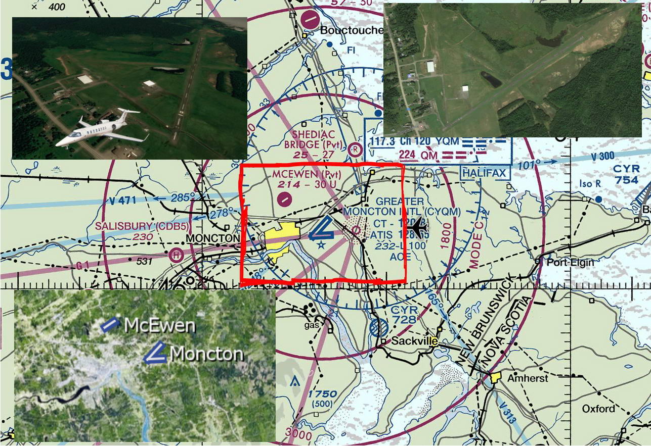
Display Morehmmm. I have never used the helper program. Meanwhile, I decided to look in at the McEwen Airport, 4 miles NW of YQM. Although is only has 3,000 feet of asphalt there is room for another 1000 feet on the East end of rwy 26. Two hangars there with a golf course literally across the street. No facilities for transits. Kathy McEwen was quite surprised to see a Lear 45 taxi up to her backyard at the edge of the airport.
She is big into motorcycles but also talks about lobsters and steaks. Great hot tub for casual conversation. I am considering making a bid to buy the little strip and start a jet charter based there. You know, bring up 3 or 4 rich dudes for some local hunting or fishing, or just a quiet get away. I have to find suitable lodging and some guides and boat charters.
I added CCG4 McEwen to the AF2 airports. Maybe we can overlay a 4,000 foot runway just for fun.
Regards,
Ray
![]()
Yes, that is more practical. So far, the size of the scenery files has not slowed down the sim so until there is some sort of impact on performance I am going for the higher resolution. I have some really large areas in the US at DL 2 or 3, 11 - 13 with the cites at dl 1.
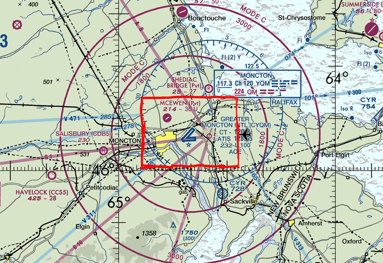
Here is the HD area for Moncton that I am using.
Regards,
Ray
I agree, my problem is that on my machine, the helper program gives me a BSOD on higher resolution jobs.
I go much lower res than that because If figure most of the flying will be up high unless around an airport. BUT that's just me.
I will do up a video tutorial after work.
BTW, Fixed up the issues with CYQM, funny part is that Moncton sign on the Tower is fine inside 3ds Max but upside down in the game, I simply flipped the bmp file vertically and it fixed it in the game YET it is still right side up in 3ds Max.
I also redid the center lines and I believe they look better now.
I also added one object to downtown Moncton for testing. The Aliant Tower.
I have also made almost all of New Brunswick with FSET textures at level 9 with level 13 around airports and in the cities.
Did you get a sufficient answer to this.
I know how I do it and it seems to work fine.
Let me know if you still need help
Right it looks like all the trees were planted by a person with severe OCD. All nicely lined up.

If I'm following the tutorial correctly. I make changes I want, click save in open street map. The lower left corner there's a Download OSMchange File link, I click it, save it, then open the with the editor. The file is changes.osc
My tutorial might be wrong, It is best to actually save the changes, exit the editor then EXPORT.
it's the .osm file I'm talking about. When I download the file from open street map the file extension is .osm, for some reason the file on the computer has the extension .osc
Does my previous post make any sense
Are you SAVING or EXPORTING. If you make a change to openstreetmap data, it will create a OSC file, FOR Open Street Change. I will look at the tutorial again, because What I do is make the change, save it, the EXPORT it outside the editor.