Posts by Ian C

    OK - thanks for your reply Antoine.

    Before I sorted out the masking issues along the boundaries between high res terrain areas I had "cliffs" that looked to be nearly 100 m high in mountainous districts - so yes, the discrepancy between default and high res terrain can be very considerable. (There was a strip of default terrain between the high res areas.) There is some even higher res data available in the USA (1/9 arcsec) but it's only available in small patches. However I was thinking that, if I do decide to use it, the discrepancy between 1/9 and 1/3 arcsec terrain shouldn't be too great - probably no more than a metre or so.

    Cheers

    Ian

    i dont know if this is the right"thread" but has someone got .spc for cultivation that puts in all trees ,airport buildings,all residential coverage ,bridges,roads highways and skyscrapers? please

    i cant code and would like to modify my current template_ver6 spc template

    thank you

    chris gard

    coxo2436

    Chris

    I got this SPC (attached) Template_ver6.txt originally from crispy136. It does most things - but probably not bridges. Bear in mind that coverage depends on the quality of the OSM data. In the USA and Australia you'll probably need to use the ScenProc "texture filter editor" to get good tree coverage. I explain how to do that here: Cultivation from photoscenery?. In the light of experience since I wrote that post I would now say: (1) You can do areas as big as level 10 quite successfully. (2) To get the BMP image I set the FSET download resolution to 5. (I don't think (?) you can use Aeroscenery to get the image because Aeroscenery doesn't give you an INF file - but maybe there is some way of doing it? Others will no doubt know.); (3) Setting the "buffer size" and "minimal feature size" both to "2" gives more precise results; (4) I haven't checked that the 2 SPC config scripts work with the latest version of ScenProc. I've been too lazy to update them and use an earlier version of ScenProc just for that purpose.

    Ian

    Thanks Antoine - that's interesting

    So far I haven't looked at what happens at the transition between high res and default. I've just stayed within my high res area.

    A couple of questions:

    (1) Where are you getting your high res terrain data for France?

    (2) Where did you get those very fine looking buildings?

    France has a lot going for it in terms of scenery creation .....

    (1) It has a wide variety of dramatic scenery.

    (2) The OSM data is very good - particularly for trees - but even buildings aren't too bad. In the USA I have to create my own tree cultivation using the ScenProc "texture filter editor".

    (3) The aerial images are good

    ..... so if I could get high res terrain data I might spend some time in France too!

    Ian

    please tell us how to do it

    Hi again Chris

    qwerty42 's video on page one of this thread is definitely your first port of call. It is very thorough and carefully explained.

    Regarding The Hood River 1x1 degree area (n46w122) .....

    Use the TMC file that I gave you for the geoconversion. Put the TFW file that I gave you into the "input_aerial_images" folder along with the TIF file that you get when you save the IMG file using QGIS. (Add layer > add raster layer > save as etc.) The TFW and TIF files should have the same name.

    Cheers

    Ian

    Hey Ian, this looks fantastic! Nice job, and glad you were able to figure out how to do it. It makes a huge difference in certain areas. One of the nice side-effects of this is that it also makes the satellite orthos look better, because they get properly stretched over the terrain shapes instead of being distorted over flat ground.

    Thanks qwerty - and many thanks to you also for figuring this out in the first place. That's true about the orthos. There are so many ways in which it makes a difference, particularly if you fly low ..... no more sloping lakes, rivers and sea, no more angles on mountain ridges, fine knobbles, ravines and hummocks modelled etc etc.

    Just an update on my experience with high res terrain mesh in the USA.

    I've managed to get rid of the discontinuities / "cliffs" between adjacent 1 x 1 degree download areas by geoconverting a 2 x 2 block of them together, using a TMC file whose NW co-ordinates are the NW corner of the northwestern-most 1x1 degree area and whose SE co-ordinates are the SE corner of the southeastern-most 1x1 degree area. I put all the TIF files and their corresponding TFW files together in the "input_aerial_images" folder. This eliminates all the masked tiles on the boundaries and pushes the problem to the outer boundary which can, of course, be as large as you like. The block could be 2 x 2, 4 x 4 or whatever.

    I've also attached a couple of comparison screenshots below. They were taken on the Elwha River SW of Port Angeles, Washington State. The top one is with the high res terrain mesh and the bottom one is with the default mesh. Note in particular the ravine, which is completely absent in the default mesh screenshot and very well defined in the high res shot.

    Hi Ian, The tutorial is still available for download. You won't see the download link to the tutorial document unless you are logged in to flight-sim.org. Once you have logged in a blue download box appears in the top right of the screen. Regards, Chris

    OK - thanks Chris - I'll try that.

    Further to my previous post on creating high res terrain mesh tiles in the Pacific North West ..... it seems that I was making a bit too much fuss about the fact that a lot of them are masked. I've now created 2 adjacent areas along the Pacific coast with a boundary at 48 degrees north. Flying down the coast I have detected no problems so far whilst crossing the boundary. It seems like the masked TTH files are different from the TTC files anyway - the TTH masked tiles aren't produced in pairs like the TTC ones are. Maybe this is why the command to reject them doesn't work in the TMC file? I'm not sure I fully understand how masked tiles work - I only know that they used to cause me enormous problems during my early attempts to create scenery, so I decided to make sure I never had any in the scenery. With the terrain mesh they don't appear to be a problem - so far!

    EDIT 14 Jan: It seems I spoke too soon. There are in fact issues along the boundaries between adjacent 1x1 degree download areas. I must have just been lucky (or unlucky) when I first looked (above). There are in fact 2 parallel rifts/discontinuities along the boundaries whose height varies according to the discrepancy between the default and the high res terrain mesh. In flat lowland areas this might scarcely be noticeable. These discontinuities look at first like vertical cliffs, until you notice that they form a perfect line in the N-S or E-W direction. The 2 discontinuities are typically a couple of km apart. This is clearly due to the masked TTH tiles at the boundaries. In the band between the discontinuites the terrain mesh is default. (I was actually expecting the strip between the discontinuities to be flat and at sea level, by analogy with the black areas caused by masked TTC files - but luckily this is not the case.)

    I'm not sure what can be done about this. It's not a massive deal given that the download areas are quite large. 1x1 degree corresponds to 100 x 60 km or so - and cliffs and default mesh are not as offensive to the eye as black strips. I wonder if there would be any way of stitching the download areas together before geoconverting them? Maybe editing the TMC file so that it encompassed a rectangle of several download areas? I haven't tried that yet. Even then there would inevitably be a boundary somewhere - just pushed further out.

    coxo2436: I followed the link in crispy136 's post but I couldn't then find any working link to the tutorial. Maybe I'm missing something. Shame the Australian page also isn't working.

    I've come a bit late to this, but I've finally given it a go using qwerty42 's tutorial video - to whom many thanks. It makes an amazing

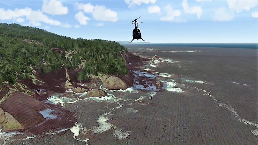
    difference - particularly to the coastline! Vertical cliffs now drop down to a perfectly level sandy beach, which is what I want to see. At 1/3 arcsec resolution (about 10 m) you'd think there would be be some slight sloping transition, but I couldn't even see that. Banished too are the sharp angled arêtes on mountain slopes. If I see any angles at all (which I rarely do) they're now on very small features like hummocks a few metres high. I tried it out using scenery I made in the far NW corner of Washington state - around Neah Bay. If only we could find a way of using similar data here in the UK. I'm probably going to be spending a lot more time flying in the USA now since it's going to be difficult for me to go back to the default resolution scenery, given that I spend all my time flying low and slow in the helicopter.

    The only thing I did differently from the video tutorial was that I converted levels 7 to 12 rather than levels 12 to 14. Later on I added levels 13 and 14 to see if it made any difference - and it didn't seem to. Having said that, it takes very little time to geoconvert these elevation tiles compared to image tiles (faster than one per second) so there's no great hardship in producing the higher levels. However, as the resolution is about 10 m, level 12 would seem to be all that's needed. There's also the question of storage space. My C-drive (containing my documents folder) is rather small in capacity. Would there be a way of moving them somewhere else as we do with the image files?

    I also wonder how I'm going to manage the transition from one these download areas to the adjacent one. The boundaries of the download areas are certain to cut through Aerofly tiles. In the area I downloaded (maybe 75 x 100 km) all the level 7, 8 and 9 tiles were masked (i.e. cut through by the boundary). Like qwerty, I want to avoid having any mask tiles so maybe the answer is to delete them all and accept that there will be no level 7 and 8 ones - only level 9 (maybe) and above. Also there will be a narrow strip along the boundary with no higher resolution tiles whatsoever. I will have to experiment and see how this looks. This issue doesn't arise with image tiles because, with those, it is possible to choose the download area.

    EDIT: I've uploaded a screenshot to show the improvement gained by using high resolution terrain mesh. This is Cape Flattery at the NW tip of Washington state. Incredibly you can see the rocks actually jutting up out of the sea!

    HI Ian, You may be using a different version of ScenProc. I'm using a ScenProc build dated 16/10/18. You can find this information right at the top of the screen after the version number. I had a look through the changelogs for Scenproc and can't see any changes to CreateAFSBuilding code since 16/10/18. Try updating and see if the problem goes away.

    OK thanks Chris - I'll try that.

    Many thanks Chris for your efforts - I'm getting very good results. One thing puzzles me slightly though ..... I get red error messages for each of the "CreateAF2Building" lines saying that 4 arguments are required. (There are 6 in your template.) I deleted the "0" at the end and one of the numbers in the middle and all worked fine. However I don't really know what I'm missing by doing that - maybe something vital for all I know!

    Thanks Ian,

    I've tried that and it seems like some of the building data is a bit off, I am expecting grass and see a building instead in some places (especially gardens). Going to have a better look to see what is causing it, need to trim the .shp files first as even one square is way too large.

    Occasionally there's a mismatch between the aerial images and the OS data if new houses have been built on a greenfield site recently. (The OS data is more up-to-date I guess.)

    The OS grid squares are very large (100x100 km). I like to have my tree separation set to 0.0001 degrees but I don't think ScenProc can cope with the large number of trees generated for some of the squares (over 15 million) - usually if there are a large numbers of buildings too. It crashes. Square TQ (containing London) is particularly problematic. I've had to reduce the tree density in some cases.

    Not sure whether you’re aware but if you’re cultivating in the UK you can use Ordnance Survey data. It’s pretty much the Gold Standard as far as cultivation goes - every building and tree clump is included. (That is unless something better has been devised since that I’m not aware of.)

    Most of the work on OS Cultivation has been done by Spit40. Search for his latest configuration file. - the one that solves the problem of the shimmering buildings.

    EDIT: Just found Spit40’s instructions and config file and put it in the post below .....

    Cheers

    Ian

    New Simplified Workflow for OS Data Cultivation

    I got ScenProc working directly from the OS data without the need to process in QGIS. Here's the full working workflow.


    1. Go to this page on OS Site
    2. Pick the squares you want data for (hold ctrl down for multiple) - check you're downloading data type:vector download ESRI shape
    3. Scroll to the bottom and click Continue, enter your details
    4. A few minutes later you get a download link for files with names like "opmplc_essh_sd.zip" (this would be for SD grid square)
    5. Unzip these files you receive and you'll find a data folder that contains files like: SD_Road.dbf, SD_Road.prj, SD_Road.shp, SD_Road.shx
    6. The SHP files are the primary ones, but keep the PRJ and SHX in the same folder
    7. Install ScenProc
    8. Now edit the file paths on lines 11,12,13,14 & 93 of the following scenproc script, save it as something like "os_data_SD.spc"
    9. Comment out lines 18-23 as necessary depending on whether your cultivation area includes airports that you have built cultivation exclusions for
    10. Load your SPC file into scenproc then run it to convert the OS Data into a TOC file for adding to your airport cultivation

    Thanks Ian C for your reply. I use this site for my OSM Data downloads which I find very good. Here is the link https://extract.bbbike.org

    This is a recent site I found for checking the OSM Data which is most interesting at times https://tools.geofabrik.de/osmi/

    As long as it doesn't upset the cultivation process I'm OK with it.

    Kindest regards, Michael.

    Hi Michael

    Many thanks for the links - I'll check them out!

    Best wishes, Ian

    I get that too when using OSM data - sometimes 3x in one run. It doesn't seem to affect my cultivation either - for example I got 13 million trees in one of my level 9 areas even after that message came up.

    It never happens when I process Ordnance Survey data (SHP files) in the UK however - and those are very big areas (100 x 100 km).

    Bing or Google must have changed something because AeroScenery used to write transparency where it detected a "no image" square.

    I'll aim to improve that for version 1.0

    I've noticed a change in Bing and Google too. I've always used the "painting-in-the-sea" method to deal with coastlines and have always set GeoConvert to reject masked tiles. Up until quite recently this worked fine, but now I find that that I'm not getting any geoconverted tiles if they include any "no image" regions - even though I've coloured those regions in. (I assume GeoConvert wants to produce a mask, so I'm not getting any tile at all since I'm rejecting masked ones.)

    I'm a bit puzzled as to why this is happening. Is the PNG storing some info about the "no-image" region even though I've painted it over? I must admit my knowledge of images and GIMP is not that great.

    The old method with FSET was to save the BMPs as TIFs after processing. I find that saving as a TIF doesn't work with AeroScenery, so I save the PNGs as PNGs - i.e. I overwrite them. Is this the right thing to do? (Even if I revert to FSET and save as TIFs I still get the same problem BTW.)

    Thanks to all who have replied. I'm using zoom level 18 so that may be slowing things down a bit (though not on the download side of things, because that only takes a couple of hours).

    I'm fairly sure that GeoConvert isn't restarting - though I have encountered that problem in the past.

    If I only go up to level 13 (using zoom level 17) it only takes a couple of hours.

    I sometimes use AeroScenery to convert a level 9 tile area with tiles from levels 9 to 14. The whole process takes about 11 hours. What I have noticed, however, is that Geoconvert slows down with time - particularly as it processes the level 14 tiles. At the beginning it is producing several level 14 tiles per minute - towards the end it is producing them at a rate of about 1 per minute.

    I have no idea why this happens. Have other people found the same thing? If it is happening to others as well it has implications regarding the most time-efficient way to use AeroScenery. It seems that it would be better to process a lot of smaller areas rather than one big area? This is not convenient at the moment because Geoconvert doesn't process areas sequentially, but when that problem is overcome it might be something to bear in mind.