Posts by uli057

    Hi Vogel.

    I dont no for Bug!

    When we make the Polygon to kml and save it,and then put in at Grid generator, the Grid Programm closed with Errors. (Program cut off)

    this mistake comes only between coordinates (google Earth grid) ...South circle from E145° to 180° and more.

    From xxx.... to 145° is all ok.

    The mistake comes in both versions!

    regards

    Once again...

    I found the mistake at Prgramm.

    At Australia east side no grid....

    South circle from E145° to 180° and more no grids... next step is South America, there was grid made

    When i go to Asia ...Japan...or west australia behind E145° he make the grid.

    LAT / Lon Mistake in Program??

    Regards

    ULI

    Hi.

    That tool is the best... and i found no errors.

    Ground for me with Level 10 or 11..... Special Tiles only Level 13.

    Run !

    My Ground Scenery goes forward, and i am at this moment work from Frankfurt to Basel....

    The rest from austria, north from Lowi runs....:) No overlapping with Pay Scenery.

    When i have made all i summary the GB for completed Ground...

    The allmost best wishes to all and specialy "Vogel69" !!!:thumbup::thumbup::thumbup:

    Regards

    Hi Michael,

    Openstreetmap is the next there i look... and at Marine Navigation we go with Openstreetmap and Esri.

    i Have a boat and there we look at our Maps in the Screen with that.

    Or we pay for Navionics, there are a lot of Deep Source at Sea, and more detail.

    But for VFR Flight we dont need big details on ground...thats only for a little orientation at 5000 Feet.

    I Take a look there....

    Hope i can find a solution for us.

    Regards

    Mhhh...

    I understand, the old problem of the releases...

    Maybe there is somebody who knows in addition something juridical?

    If one cannot deliver it as a Freeware, I get no money for it... then I cannot make available it to all, of course.

    Why must this be always thus complicated?:(

    Why we must always make everything twice... everybody has for itself always anew, although it somebody quite ready there lie.:(

    Let us hope that i can my work for all ....as Freeware downloadable in future ?!?!? i dont no !

    Regards

    ULI

    Tip for Lenid...

    when you use a Picture with Alpha Channel you must set in Geoconverter the point "create Mask", in FSET no create mask!

    The Alphachannel is then in a new generated Picture as xxx.tif no compressing when you save.

    When you dont use Mask you see at Aeroflight no Groundpicture with his Alphachannel....

    For Level 9 at Aeroflight you set the Resolution at FSET to 4.

    In geoconvert set the Level 9 and 10 for this Resolution.

    For Level 13 in Aeroflight you set the Resolution at FSET to 0.

    In Geoconvert set the Level to 12 or 13 for this Resolution.

    And ...important at geoconvert...with Alpha Pictures ...."create Mask".... without Aplha Chanel no create mask.


    Regards

    Hi Lenidcamper and Michael.

    Lenidcamper....

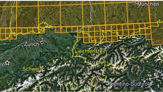
    Please see the atached picture for what i generated.

    You see the Level 9 tiles, and you see the Level 11 Tiles for Austria.

    Level 11 Tiles for austria is why the LOWI Scenery is made on Ground with Level 11.

    When you make your own scenery ...it is okay,

    Or, you orientate at my Bounderies for the rest from your own Scenery for Italian and so on.

    Make only for Airports and points of interssting the Level 13 Tiles....not completed for all.

    For fly over Ground at Flylevel 5000Feet it is enough with Level 9-10.

    maybe we can use in future together the Scenery... then fits everything. At the moment we may put nothing online....

    Ch Pay Scenery is at Level 13 compiled.

    Lowi Pay Scenery is compiled at Level 11.

    Michael...what you mean with "I am afraid you can't redistribute it, can you?"

    when i ready with Germany i bring this as free at Server for all....

    Regards ULI

    Hi...

    The excel sheet i look forward and work with... THX !!

    "Vogel69"

    That what you present with Vid have i made, but you copy tile for tile at FSET.

    I have the goggle N/W Tile copy coordinates in FSET and i have copy from Google the S/E coordinates to FSET.

    The Tiles are also show, but for copy (manual insert 2 Point) i must calculate in Aero/FSET Coordinates new.

    And there is diffrent for coordinates between google and FSET.... a little bit diffrent.

    i must after 50°. xxxxxxx all numbers set... for right calculate in example " N50° 26 24.55" at FSET

    i am learn and i learn more when i tested self....than i understand this Aero tiles...;)

    but many thx for all that help here in this forum !!!!:):thumbup:

    Regards

    uli

    Hi ..

    The mask dont covered the partielly scenery tiles....the overlapping exist to.

    Aero has his own tiles...and at Startpoint in Aero we can see....zoom in... the tile borders from aero. But this, dont help in FSET.

    When generated with FSET we have the Probs with overlapping tiles every time.

    Only a chancewe have, is, that made a big Ground tile (cpl- Germany) at Detail 4 and compile with max Level 9-10.

    After this, compile the next tiles for better view a small tile ( Airport) at Detail 0 and Level 13-14, only one.

    That goes...but when you want more tiles after the first procedur.... the same Problems with overlapping tiles comes true.;(

    FSET is not specialy for AeroFS2...;)

    We can work with this, but it is very ticky...

    I wish and hope that we become a Tile Tool that bring us the correct Tile coordinates for Aero FS....8)

    Regards

    hi,

    wieviel BGl Dateien willste haben für Airports ZB. "Sevenrow" alle Ostfriesischen Inseln ?

    Die Scenery war von mir aus dem FSX plus ...Sylt...

    Texturen gibts dazu...;)

    Gibt noch mehr...habe noch alles :)

    Im Screenshot Ordner gibts schon mal die Ansicht von den Ostfris. Inseln per Ground Textur im AFS2

    Ich kompiliere die Ground nur noch im Detail 4 mit Level 9 und 10.

    Klappt prima braucht wenig Platz und reicht fürs überfliegen nach VFR.

    Gruss ULi