Posts by ApfelFlieger

    admin

    Yesterday I finished designing my KNHU airfield, which is compact in terms of surface area. In the process I noticed:

    • Several times when creating lines I got the error message that saving was not possible because of line errors.
      => I then closed the tool, deleted the tab and opened the tool again. I did not log off and log back on each time.
      => Each time I restarted, however, the KNHU aerodrome then showed lines that I had entered, but which supposedly could not be saved because of errors with the lines.
    • I continued to work on this basis. When I then wanted to position the lines exactly with a high zoom resolution, I noticed that many lines were now present up to 3x.
      => Therefore, I then deleted the copies in the tool for the lines that I wanted to correct. :)
    • This morning I looked at the KHNU.tap with a text editor and searched for duplicates (via CTRL+F and search for identical contents in the lines "<[vector2_float64][position][]>".
      => I found a lot of duplications in tarmacs and lines. ;(
    • By hand I then created a KHNU.tap cleaned of the duplicates. and then wanted to upload this after deleting the original KNHU.tap with duplicates.
      => Unfortunately, the import of the cleaned-up KNHU.tap no longer works. :(

    I am attaching all the files concerned as a zip file:

    • KNHU.tap:
      -I have cleaned this file of duplicates.
      => Now I would like to import it again -- but unfortunately this does not work. :/

      EDIT:
      After another revision, I was able to import KNHU.tap again. However, I did not discover any errors, I just redesigned the structure cleanly.

    • KNHU___ORIGINAL_20230223_083500.tap:
      - This file is the last version I downloaded before deleting it from the tool.
    • KNHU___MULTIPLE_TARMACS_MARKED.tap:
      - In this file I have marked the duplications in the tarmarcs as an example.

    With FSCloudPort, there has been something we can learn from for years :) . It shows that there are different demands of airfield developers, some only want the runway, others want the runway, tower and some buildings and others want all buildings and a lot of other details besides the runway. In the meantime, this leads to the fact that FSCloudPort sometimes has the same airfields several times :( , which is not always easy to understand for newcomers.

    For the future, I can well imagine a combination solution:

    - IPACS first offers a tool for everyone to create airfields.

    - When airfields created in this way have reached a level that is still to be defined, IPACS will transfer them (of course only in agreement with the creator) into a kind of official certified user database.

    We come back to the same discussion as with the UH-60 :)

    I do not understand why not to use the (G) being that this one is only intended for the retraction of the wheels?

    Which is not the case with these two models.

    Well, as long as you get a key, the D or another, would also do the trick. ;)

    All aircraft with retractable landing gear use "G" to operate the landing gear. My experience in the field of software is that it always proves to be a hindrance at some point if standard functions are then assigned differently.

    If there are one or more buttons for the door(s), there will certainly be a desire to use these buttons on aircraft with retractable landing gear at some point -- and then?

    In the long run, it will be a good idea to have different buttons for different functions.


    EDIT:

    But independently, all button assignments must be done via CONTROLS and must not be "hardwired" into an aircraft.

    chrispriv

    Quote
    • I couldn't first figure out how to rotate the parking spots and helipad seems (shift and mouse wheel). It would be useful to add a corresponding field under "Edit Parkingspot/Helipad" containing the rotation similar to "Edit Building" and "Edit Aircraft"

    I hadn't thought of that before, thank you for pointing it out. :) On a MacBook it works with SHIFT and two fingers on the trackpad. :thumbup:

    I have further points:


    I RECOMMEND SAVING AFTER EACH STEP

    I have now got into the habit of saving after each action. Especially with more complex lines and tarmacs it is helpful to save after each line or group of lines as well as after each tarmac to get direct feedback if there is an error that prevents saving.


    "MOVE" BUTTONS MISSING

    When editing my compact airfield KNHU I wanted to set some drag points more precisely afterwards. To do this, I zoomed very far into the airfield using the trackpad. Unfortunately, moving the map then no longer works if I don't have an original area of the map where I can access with the virtual left mouse button of the trackpad. Because if only tarmacs are visible, I always move only the tarmacs.

    As an alternative, I then try to zoom out of the view until I have an original map again and then move the map there.

    => It would be good to have 4 buttons with which you can move the map left-right/up-down, even if there is no map surface to grab.


    "ZOOM" BUTTONS MISSING

    When zooming the map via the trackpad, there are sometimes relatively large jumps.

    => 2 buttons for zooming in and out would be good.


    "UNDO" BUTTON MISSING

    When accidentally moving the tarmacs, I noticed that there is no way to undo an accidental move in the software.

    => It would be good if there were 2 buttons for undoing and unundoing.


    WHY TAMAC UNDER BUILDINGS?

    In the article above on the RJ04 airfield it is pointed out that it is advisable to create an tarmac area under buildings.

    My questions:

    - Does this level the surface?

    - Or is it just for visual reasons that a building is not placed somewhere on the images in a place where it just looks stupid?

    admin

    I still have some questions/suggestions/wishes: :)


    PAPI

    Currently the PAPI allows you to select whether they are set by default or custom set by the user with position, width and angle, e.g. ...

    Code
                    <[string8][papi1][left]>
                    <[string8][papi2][none]>
                    <[bool][papi1_has_custom_position][true]>
                    <[bool][papi2_has_custom_position][false]>
                    <[vector2_float64][papi1_custom_position][-4.179356 47.975760]>
                    <[vector2_float64][papi2_custom_position][0 0]>
                    <[float64][papi1_glide_slope][3]>
                    <[float64][papi2_glide_slope][]>
                    <[float64][papi1_spacing][9]>
                    <[float64][papi2_spacing][]>

    => I think it is good if this will continue to be possible.


    POSITION OF THE AIRPORT

    In addition to my point yesterday on this, I propose the data "<[vector2_float64][model_center][]> (airfield coordinates) are

    - displayed in the AIRPORT DATA menu and if possible can also be changed there (I mostly use the data of the AERODROME CHARTS) as well as

    - be shown on the map with a destination point marker as with FSCloudPort.


    RUNWAY ALSO WITHOUT MATERIAL

    I use airfields for which there are (very) good images without artificial runway.

    => Therefore, I would be happy if it were possible to create "transparent" artificial runways.

    Moin Moin to all,

    I currently only see ESMS and my three airfields KNGU, KNHU and EDXE (for higgy ) in my airport overview.

    Now we could test the next step and work on one airfield with several using the Invite function.

    This leads me to ask the admin :

    - Is it already possible to work on several airfields at the same time?

    - How is the overview of all airfields planned? Can I filter by "only my airfields" and "all airfields"? I don't want several people to work at the same aerodrome and not know that others are already doing the same.

    I am curious to see how well the conversion of the tap files into the files for FS4 (and FS2?) works.😎

    admin :

    - When drawing lines I have no problem setting multiple points for curves, an arc function would reduce the data volume of the coordinates somewhat.😀

    - I like the possibility of delimiting the airfield at least visually on the map. Unfortunately, I have a tendency to want to do it exactly😱, which of course increases the data volume of the coordinates.🫣🤭

    I continue with the individual menu items:

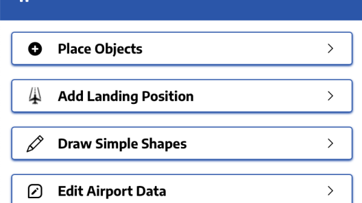
    I am simply bothered by the activity words in the first 4 menus. I suggest omitting the words "Place", "Add", "Draw" and "Edit".


    GENERAL FOR ALL MENUS

    In general, I find the images and fonts in the selection catalogue sometimes a bit difficult to recognise. Therefore I suggest

    - when hovering the mouse over an element, it should be clearly enlarged, e.g. factor 4

    - on the catalogue pictures the background should be light and no longer dark

    - in all catalogues there should be a search function, which is currently only available for the aeroplanes

    the drag marks on objects are partly not in the optical centre of the objects (where they make most sense), but partly at the edge, e.g. on "Techhouse01 4.02 x 3.81" in a corner of the object.

    For all lines, the catchment area for marking a line is too narrow in my opinion. You have to hit a line very precisely in order to edit it.

    For all objects that can be rotated, a drag point for rotating the object would be helpful.

    During the dragging of an object, not only should the dragging point be moved and the object remain at the previous location, but it should constantly move along with the dragging point. At the moment, exact placement is a bit tedious.

    It should be possible to move marked objects not only with the mouse but also with the arrow keys.

    If objects are marked in the catalogue, it should be possible to place them directly on the map with a double click.


    MENU "(PLACE) OBJECTS"

    AIRCRAFTS

    If you have already placed an aircraft and want to place another, but different one, you must first go out of the AIRCRAFTS submenu and then back in again to place the new aircraft. Because if you only select the new aircraft in the catalogue, the one already set changes.

    For the other objects it works normally.


    MENU "(ADD) LANDING POSITION"

    RUNWAY

    When placing a runway, the window "Edit Runway" can be opened at the same time.

    Basically, the runway material should be set to "Runway Asphalt standard" by default. With the first runway I created, I had to search for a long time before I realised that the absence of the material prevented it from being saved.

    For purely informative purposes, the length of the runway could be displayed in addition to its width.

    In the PAPI the selection "both" is missing.

    HELIPAD

    The orientation for the helipad position is still missing.

    There should be different variants for heliports in the markings.

    PARKINGSPOT

    The orientation for the parking spot is still missing.

    In addition to "parked_jet" (40 m radius) and "parked_ga" (7.5 m radius), "parked_heli" with e.g. 15 m radius should be added to the type.


    MENU "(DRAW) SIMPLE SHAPES"

    When the submenu "(Draw) Line" is selected, the other submenu "(Draw) Tarmac" remains highlighted. However, drawing lines still works.

    (DRAW) LINE

    If you want to draw an asymmetrical line such as a holding line, you cannot subsequently rotate the orientation by 180°. In the direction of drawing, the broken line is always on the left and the solid line on the right. A simple swap should be possible here.

    Currently, only angular polygons can be drawn with the automatically appearing handles. It would be good if you could also form arcs.


    MENU "(EDIT) AIRPORT DATA"

    (DRAW) AIRPORT BOUNDS

    When closing the boundary (set last draw point exactly (!) to first draw point), it is not always easy.

    That's why I suggest that surfaces should always have an enclosed border, e.g. in the form of a quadrilateral, because the automatic handles between two corner points allow all shapes to be drawn.


    Basically, I'm already through with trying and testing. I enjoyed it and I think we can look forward to a good tool. I'm curious to see to what extent the tool can also be used on a tablet.


    Tschüss, Michael

    INTRODUCTION

    I find that you are left a bit alone with the introduction via "Dashboard" and don't really know what to do next:

    I think it's better to start via "Airports" because you have the feeling that you can start right away:


    PAGE "AIRPORTS"

    I think it would make sense to add the button "New Airport" to the button "Import Airport" (see picture above), which jumps into the map like the button "View on Map" and then permanently shows the hint "Right Click Ma to create an Airport".


    FIRST CREATION OF AN AERODROME

    When creating a new aerodrome, it should also be possible to directly enter the TLD of the country in the field "Country".

    After entering the data shown Country, Name and ICAO, the airfield can already be saved, but then the localization is missing, to find it on the map.

    This happened to me when creating KNHU and I was then able to catch up on the localisation by means of export, manual data correction and subsequent import.


    IMPORT OF AIRFIELDS

    When importing an already existing aerodrome, the following messages appear one below the other

    - "Airport with icao ICAO allready exist" and

    - "Airport imported seccessfully",

    which does not fit together. In fact, no import of an already existing aerodrome takes place.


    PARALLEL CREATION OF IDENTICAL AERODROMES

    As in FSCloudPort, identical airfields can be created under different names. In the long term, this can certainly only be limited by moderation.


    DEACTIVATE AIRFIELDS

    I am in favour of deactivating airfields in order to work on them in peace, for example. Then they should be listed, but not be able to be used by third parties.


    VISIBILITY OF CHANGELOG

    I think changelog is good in general, but I think there should be the possibility that it is not publicly visible.


    SAVING AIRPORTS

    When saving, the view "Saving Airport" should come up first and show whether all data fit.

    If data does not fit, there should not only be a RED X in the affected area, but it should be shown more concretely what does not fit, because otherwise one might search oneself silly.

    Only when everything is GREEN does the text field for change notes make sense -- actually, it could also be directly under "Saving Airport".

    There should also be active feedback that it has been saved.


    OUTPUT OF THE FILES

    I think it would be good if in the future, too, the files were generally editable with a text editor.

    And for the automatic structure of the files I would like to see a clearer outline and not so unstructured:


    These are my first points. Detailed points will follow little by little. :)

    IPACS has recommended that I share my feedback here on the forum so that others can share it.

    I applied to be an alpha tester because I am interested in the topic and have been designing dozens of airfields of various sizes in FSCloudPort for years. ^^

    After I got access from IPACS, I first had a look at their "demo" airfield EMSM (Malmö International) to get a first impression. Then I exported ESMS, added the data from KNGU (an airfield I created in FSCloudPort in Norfolk, USA) and imported it again. In addition, I also created KNHU (also Norfolk, USA) using the "Create new airfield" function. All in all, I have taken a few hours to become familiar with the tool. :)

    My first general impression:

    I think the alpha version is already well done for us users :) and I have no problems creating complex airfields with it right now :) . Those who are "at home" with FSCloudport will, in my opinion, quickly get to grips with the new tool.

    => Therefore, a big praise in advance to all those involved. :thumbup:

    I will now post my comments on the individual points in separate articles. This will be done exclusively in the sense of a positive critical test in order to prepare a good way for this tool.🚧 8)