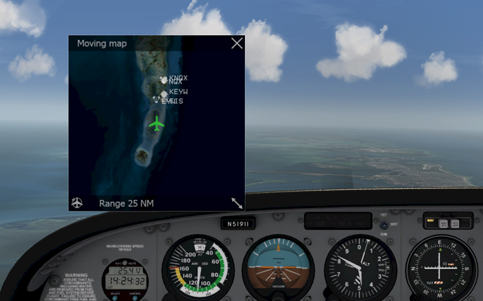
IPACS

Addition Flight Information As Overlay

Aerofly FS offers several optional overlays that show additional information in front of the actual simulation.

Overlays

Moving Map

The moving map is a top down view of your surroundings. It shows nearby airports and navigation aids on top of the aerial images.

The default key shortcut to show or hide the map is ‘m’.

  • Move your mouse cursor over the moving map and scroll with your mouse wheel to change the map zoom.
  • With the mouse cursor over the map hold down the left mouse button and move your mouse to drag the moving map across the screen.
  • Grab the lower right corner of the map and drag it to resize the map overlay.
  • Click the compass symbol in the lower left corner to set the orientation of the map to north-up. Click it again to constantly rotate the map with the current aircraft heading (heading-up).
  • Click X-button in the top right to close the map.

Flight Info Bar

The flight info bar shows valuable information to control the aircraft without looking at the instruments in the virtual cockpit.

With the default short-cut ‘i’ the flight info bar is shown or hidden.

It shows from left to right:

  1. Wind direction and speed
  2. Selected flap position
  3. Throttle position
  4. Magnetic heading
  5. Indicated airspeed
  6. Attitude
  7. Barometric altitude
  8. Height above ground
  9. Vertical speed
  10. Nearest airport or route
  • Click the top left back arrow to return to the main menu.
  • Click the top right double bar button to pause or unpause the simulation.

HUD

Aerofly FS offers a virtual heads up display (HUD) that can be overlayed on screen or in virtual reality (VR). It is visible in the cockpit and also when you pan around the outside of aircraft.

The default shortcut to show or hide the HUD is ‘h’.

The HUD shows information such as an attitude indicator and the flight path vector in the center of the screen, an airspeed tape with airspeed and airspeed trend as well as mach number and ground speed on the left side, the current throttle position on the far left, an altitude tape on the right side along with the vertical speed, selected altitude and radar altitude.

When the view is tilted down a navigation display comes into view. Inside a compass rose that shows the heading of the aircraft there is a map area that displays nearby airports and the flight route.