Posts by flightxtreme

    and i mean... If you look at this:

    External Content m.youtube.com
    Content embedded from external sources will not be displayed without your consent.
    Through the activation of external content, you agree that personal data may be transferred to third party platforms. We have provided more information on this in our privacy policy.

    there IS a lot of reflection for real.

    I also wouldn't recommend inverted flight right off the bat. ;)

    no inverted flight? Doo.... :D

    External Content m.youtube.com
    Content embedded from external sources will not be displayed without your consent.
    Through the activation of external content, you agree that personal data may be transferred to third party platforms. We have provided more information on this in our privacy policy.

    Ah nein... zwei Sachen. Das eine ist die Auflösung für FSET. Da gilt ja 0 -> 0.5 m/Px, 1 -> 1 m/Pix und so weiter.

    Das kennst du ja.

    Dann benutze ich den GeoConvertHelper, der die AFFS2 Level 9, 10, 11.... 15 unterstützt. Das ist die Auflösung der Kachelungen in AFFS2.

    Hier hat 14 etwa eine Auflösung von 1 m pro pixel.

    Das kann man sich in etwa so vorstellen: Die Welt wird mit einer Bitmap in Level 0 dargestellt (nagele mich nicht darauf fest). Dann wird es geviertelt: Level 1. Jeder dieser Bereiche wieder geviertelt: Level 2... und so weiter.

    Wenn du diese Bereiche immer komplett abdeckst, dann kommt der AFFS 2 am besten damit zurecht und du brauchst auch keine Masken.

    Um diese Kacheln zu berechnen verwende ich das worldgridcoords Excel (beide Tools gibt es hier im Download oder unter https://flight-sim.org/.

    Für meine Szenerie-Packete habe ich mich für Level 7 Kacheln entschieden. Die Cultivations haben eine Größe von Level 10. Das kannst du dann auch anhand der Dateinamen sehen.

    Hoffe, das klärt es etwas auf.

    Gruß,

    Micha

    Hallo Sebastian, ja, so musst du die Fotoszenerie bauen. Du kannst sie auch mit Level 0 im FSET herunter laden, allerdings hast du dann sehr große Datenmengen. Ich mache das bei mir auf dem ganzen Gebiet so, dass ich mit Level 9 (10 ist nicht unbedingt notwendig) 11 und 12 kompilieren kann. Die beiden Level 13 und 14 erzeuge ich immer direkt um die Flugplätze. Wenn es die Quellen hergeben würden auch 15. Auf Masken musst du so nicht achten, ich halte mich bei der ganzen Sachen an die Kacheln von AFFS2. Wenn das alle machen, dann passt auch immer alles zusammen.

    If someone want to test before I upload it:

    http://www.flightxtreme.com/L7_8800_A600_V1.0.zip

    Aerofly FS 2 Addon Scenery flightXtreme

    Included are 57 (very) basic airport data and cultivation of the whole area.

    This is the first part of scenery I try to build for the Aerofly FS 2.

    I decided to make Level 7 Parts to make a manageable aera as well as a suitable size

    for your foto scenery. Sadly I cannot provide you with the foto scenery. You need to

    build it on your own, tools an help can be found on the IPACS Aerofly homepage.

    If you have already an airport scenery in this area, simply rename

    the ...tsc file to ...off so the file from this package will not be used by the sim.

    Install: Copy the scenery folder into your addon folder of your aerofly fs 2.

    If you have improved airport files or other landscape objects you want to provide,

    so I can include it into a future package, it is welcome.

    Use it on your own risk, I take no warranty.

    (c) 2018 flightXtreme

    micha@flightxtreme.com

    ----------------------------------------------------------------------------------------

    If you want the photo scenery, use this data to build it for example with the tool FSET:
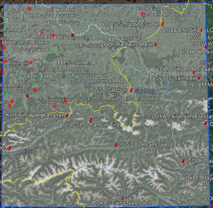
    Area
    Name: 8800_A600 Level: 7 Ref Point:

    Latitude: 46.7444003950914

    Longitude: 11.25 BoundingBox: (minX;maxX;minY;maxY)

    11.25;14.0625;46.7444003950914;48.6138704750471 Height: 207.719 km

    Top width: 206.603 km

    Bottom width: 214.142 km
    ----------------------------------------------------------------------------------------

    Airportlist:

    EDS029_Kochel_am_See

    LOWI_Innsbruck-Kranebitten

    EDMO_Oberpfaffenhofen

    EDP002_Warngau

    EDP003_Neubiberg

    EDS030_Benediktbeurern

    EDS031_Greiling

    EDS032_Koenigsdorf

    EDU016_Kleinhartpenning

    EDU017_Sollach

    EDU018_Antdorf

    EDDM_Munich

    EDMD_Dachau-Groebenried

    EDNX_Oberschleissheim

    EDPI_Moosburg auf der Kippe

    EDS005_Gammelsdorf

    EDU004_Eschelbach

    EDU005_Altomuenster

    EDU006_Strassham

    ETSE_Erding_AB

    ETSF_Fuerstenfeldbruck_AB

    EDS025_Geitau

    LOIJ_StJohann

    LOIK-Kufstein-Langenkampfen

    EDJG_Grabenstaett-Chiemsee

    EDNV_Vogtareuth

    EDP001_Edling

    EDPC_Bad Endorf

    EDPK_Schoenberg

    EDS014_Unterwoessen

    EDS026_Brannenburg

    EDS027_Flintsbach-Riesenkopf_X

    EDS028_Antersberg

    EDML-Landshut-Ellermuehle

    EDMP-Vilsbiburg

    EDMY-Muehldorf

    EDNA-Ampfing-Waldkraiburg

    EDS007_Altoetting

    EDU011_Wasentegernbach

    EDU012_Loiperstaett

    LOKL_Lienz Nikolsdorf

    LOWZ_Zell am See

    EDS013_Teisendorf-Pank

    LOWS_Salzburg

    EDME_Eggenfelden

    EDMF_Fuerstenzell

    EDNK_Kirchdorf-Inn

    EDNP_Pfarrkirchen

    EDU014_Kleinthann

    LOLK_Ried-Kirchheim

    LOSM_Mauterndorf

    LOGO_Niederoeblarn

    LOLC_Scharnstein

    LOLU_Gmunden-Laarkirchen

    LOLE_Eferding

    LOLS_Schaerding-Suben

    LOLW_Wels


    Ah well, most stuff from the code was already done by my cultivation - object exclude tool, so it took only half a day to finish the first version of the editor.

    It is always driven by my personal needs to write tools. For the editor it is simply the need to edit a lot of tsc files with backup functionality and notepad or WordPad or something similar is not very handy. I don't expect you to change the general syntax of such files, so it does not get useless - for me.

    By the way... "generate the airport runways from some database" - done so already, looks nice to see all the airports around the world. ;) Tough, I got rid of them because of the long loading time and it does not make sense without photo scenery.