
Thank you everyone that voted. The poll is now closed; we don't want any of that good stuff coming to Aerofly FS2 to make it even a harder decision ![]()
Posts by drhotwing1 (IPACS)
-
-
You should post this in the mobile version's forum.
-
You can basically define any new hard drive location between the [] brackets. You can also adds any subfolder that is inside of your user\documents\Aerofly folder into this new location and Aerofly FS2 will scan that location for scenery, aircraft repaints, etc.
This will allow for users with smaller root drives (where your documents folder resides) to place their scenery, airports, repaint etc. to a different hard drive.
-
I've never tested this myself so I can't be certain, but if your panels are USB driven it should be recognized within Aerofly. If not, I can see if that particular device can be made to work, but I can't promise anything at the moment.
-

Does the USGS service include data for countries different than the US, or it's restricted to USA?. I ask because in this community a lot of people live outside the US
Cheers, Ed
USGS is primarily US territory
-
You can now define a custom user folder by adding your location to the field: <[string8][extra_user_folder][]> located within the main.mcf file. The location can be defined by placing it within the brackets of the command and saved.
For defining a custom scenery location the location must contain the sub-folder “scenery”. This will give you the ability to place your custom scenery in a location other than the documents folder located on the root drive. This will allow for Aerofly FS2 to scan for any image files in that location.
-

Hi, this is my first post on IPACS. I purchased AeroFly2 during the sale and was so impressed on how well it runs on my lap top I bought all that steam had to offer during the sale. I just want to thank you for this discussion on the joystick settings. Most helpful. Also was surprised how well the Orbx scenery works as well.
Kind regards,
Carl
Hi Carl, welcome to our forum ! Be sure to check out the official Aerofly FS2 Wiki as well, it contains an up to date user manual, tutorials, and much more. Also be sure to grab some user created repaints on this forum for your favorite aircraft.
You can find the Wiki here: https://www.aerofly.com/aerofly_fs_2/dokuwiki/
-

its not from a wiki- its from their terms and conditions page
I wasn't talking about the link in your post.
-
Happy 4th of July!
-
Display More
we should able to share anything you make with no legal issues, its all public domain if ur getting it from USGS
"USGS-authored or produced data and information are considered to be in the U.S. public domain." The satellite imagery is fair game guys the images on the site arnt but the satellites are. We just need to credit them
"When using information from USGS information products, publications, or Web sites, we ask that proper credit be given. Credit can be provided by including a citation such as the following:
Credit: U.S. Geological Survey
Department of the Interior/USGS
U.S. Geological Survey/photo by Jane Doe (if the photographer/artist is known)"heres the link https://www2.usgs.gov/laws/info_policies.html
The disclaimer posted on the Wiki is derived from legal opinion based upon American copyright law in order to protect IPACS from any user misuse. If you choose to share any sceneries made using FSET, that's fine, as IPACS has only released a tool to convert aerial imagery from ANY origin into Aerofly FS2.
-
Aerofly FS2 is still fully under development and there will be much more to be released in future updates.
Following the ORBX partnership with IPACS and their inauguration releases of LOWI and Meigs Field, there is a lot going on regarding upcoming updates. One update is a much anticipated release of the Dash 8 Q-400 aircraft. At the same time, there is building anticipation around the upcoming new GeoConvert tool, which is a part of the SDK program to allow for more user interaction within Aerofly FS2. This new tool will allow for any user to make their own scenery for FS2 and put it into the sim using a fairly easy process.
IPACS isn't asking the community to make scenery for FS2, but rather will be providing a tool to do so if you may choose.
ORBX will continue to make wonderful scenery for Aerofly moving forward, and as development continues, expect even more great things coming in the future.
You have certainly chosen the correct horse here

-

Well, in that example waters aren't blended, there's a sharp watermask limit. We need to design a soft, progressive blending for the water texture (when there's one) to come up to the shore, and the areial picture with undersea details to show and progressively fade into deeper waters, like in FSX/P3D.
Cheers
Antoine
I just provided that as a quick example. The actual scenery shown in that example is indeed blended and fades into the default water.
-
is rodeo a dev?? if not- is he giving out scenery???? or selling it????
Rodeo is an internal member working with Torsten, myself and the rest of the IPACS team. He is also a very strong contributor to the Aerofly FS2 community. With that said, no one is selling scenery. We may provide a couple of "demo" sceneries made from the GeoConvert tool to promote the tool, but other than that we expect the community to make their own scenery moving forward for their own use and pleasure. It's still too early to tell if a way to distribute user made scenery is an option at this time.
The GeoConvert tool will provide an easy, somewhat automated way to make and implement scenery for Aerofly FS2 as part of the SDK development cycle.
-
what can easily be exchanged is the FSET setup and inf files for anyone to download the orthophotos and compile them into a scenery.
The hardest work however resides in manually tuning the base photos in order to get colors that match existing sceneries, and draw the masks for water (Bodensee is much damaged in the Swiss DLC, just as the lake Geneva)...
Cheers
Antoine
For the water masks, you can easily edit the water using alpha layer in Gimp. Aerofly FS2 uses alpha blending. Here's a photo of my Key West scenery taking advantage of Gimp and alpha layering.
-
Welcome to the forum! Dash 8Q-400 is on deck for release.
If you are interested in liveries, head over to the "User Created" section of the forum, there are some really nice new liveries for FS2 aircraft.
-

Hi, it would be awesome if the gap between Switzerland & Innsbruck could be cover in a better resolution.
Thanks, Ben
One of my tests included this directly and it works very well. The GeoConvert tool has the ability to overlap existing scenery including DLC as well, however, without further testing I'm not certain if there are any underlying issues that I didn't catch just yet. I'm just not too sure how this is going to be handled yet.
-

I will have to take a much closer look when the tool arrives, since there seems to be some building apprehension out there about the complexity of the process. If I can do it, anyone can!
You can do it Devon
-
Gentlemen,
the entire scenery creation process is truly fairly simple and straight forward if you carefully follow the tutorial on the Wiki.
For making high quality scenery spending an hour going through a rather easy process should be worth it for many of you out there.
-
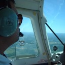
Here are a couple of screenshots showing some alpha blending techniques along with the GeoConvert tool. These shots are taken flying out of Marathon International Airport near Key West.
-
 Display More
I have created my first FS EARTH TIles BMP files and they are stored in the work folder.
Now I am looking for the TMC file. It is menbtioned in the tutorial that there is an example TMC file but its not mentioned what name the example file has.
Looking around in the SDK folders I found: content_converter_config.TMC which looks similar but when opened doesn`t really match the screenshot.
The screenshot file is named config-region-fallon.tmc but that one I cant find anywhere. I guess this is the example one.
Should I manually input the structure from:
https://www.aerofly.com/aerofly_fs_2/d…cenery_creation
and then input my own filename and coordinates or is there a template available?
Regards,
Stefan
The sample file will be released with the GeoConvert tool. It will be easier to just use a sample file and edit it accordingly. The structure will look like this though.
Hint- it's actually a sample TMC file
<[file][][]
<[tmcolormap_regions][][]
<[bool] [write_ttc_files][true]>
<[string8][folder_destination_ttc][./scenery/images/]>
<[bool] [always_overwrite][true]>
<[list][region_list][]
<[tmcolormap_region][element][0]<[uint32] [level] [9]>
<[vector2_float64] [lonlat_min] [-81.84 24.52]>
<[vector2_float64] [lonlat_max] [-81.71 24.60]>
>
<[tmcolormap_region][element][0]<[uint32] [level] [11]>
<[vector2_float64] [lonlat_min] [-81.84 24.52]>
<[vector2_float64] [lonlat_max] [-81.71 24.60]>
>
<[tmcolormap_region][element][0]<[uint32] [level] [12]>
<[vector2_float64] [lonlat_min] [-81.84 24.52]>
<[vector2_float64] [lonlat_max] [-81.71 24.60]>
>
<[tmcolormap_region][element][0]<[uint32] [level] [13]>
<[vector2_float64] [lonlat_min] [-81.84 24.52]>
<[vector2_float64] [lonlat_max] [-81.71 24.60]>
>
<[tmcolormap_region][element][0]<[uint32] [level] [14]>
<[vector2_float64] [lonlat_min] [-81.84 24.52]>
<[vector2_float64] [lonlat_max] [-81.71 24.60]>
>
>
>
>