Below is an explanation of how to do a quick, back-of-the-napkin calculation for when to begin descents.
Aerofly FS 2 is really nice in that the distance to your destination, and distance to the next way-point, are displayed once you create a flight plan.
Typically I fly the A320, but it seems to work for any of the commercial jets, more or less.
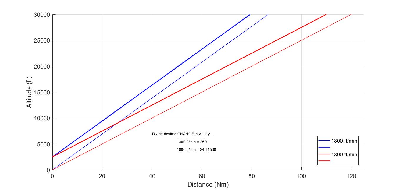
Through trial and error I found that starting at 10000 feet with a descent rate of 1300 ft/min, I had to begin my descent at around 40 Nm from where I wanted to be. Given a starting altitude, I could find the ratio of a new descent rate to the 1300 ft/min to back out the slopes. See the attached image.
Steps
- Determine starting and ending altitudes; then find the difference (total descent)
- Find the slope: 1800 ft/min = 346.1538; 1300 ft/min = 250 ; Any others = (new/1300)*250
- Divide the answer in #1 by the slope found in #2
Notice, the ratio of the descent rates is equal to the ratio of the slopes; hence, we can find any descent rate's corresponding slope. For example, let's say we wanted to descend at 1000 ft/min, (1000/1300)*250 = 192.308.
So, if I were cruising at 25000 feet, and wanted to descend to 2500 feet at a rate of 1800 ft/min, I would need to begin my descent 65 Nm out from the target way-point.
i.e. (25000-2500)/346.1538 = 65.
For the same scenario, if I wanted to descend at 1200 ft/min, I would need to begin my descent 97.5 Nm out from the target way-point. i.e. (25000-2500)/[(1200/1300)*250]
In the attached image, two lines are shown for each descent rate. The bold line indicates descents to 2500 ft for final approach, whereas the light weight line indicates descents to ground level.
NOTE: Different airports have different ground elevations, obviously. This needs to be taken into account, so your ending altitude will be higher and your total descent will be smaller. Also you have to watch your speed, this usually works for me if I also use the slope to decrease my speed from 300 knots to 150 knots gradually.