

Cayman Islands Freeware Project:
Converted and updated FS2 version for Aerofly FS4.
Many thanks Jake, for sharing your great scenery with all the objects and animations adapted to work on FS4 too! ![]()
![]()
Christophe
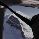
Cayman Islands Freeware Project:
Converted and updated FS2 version for Aerofly FS4.
Many thanks Jake, for sharing your great scenery with all the objects and animations adapted to work on FS4 too! ![]()
![]()
Christophe
POI's for Switzerland available on flight-sim.org for contributors.
There are a lot of POI's to discover in Switzerland. Complementary to IPACS streamed cultivation for FS4, this collection contains over 200 objects at approx. 50 locations enhancing the scenery.
It includes many cities such as Zurich, Bern, Basel, Lucerne, Neuchâtel and Geneva. It also has mountain stations such as the Jungfraujoch, Gornergrat, Pilatus, Mythen, Diavolezza, also castles e.g. in Sion, many hospitals and dams, stadiums, monasteries and much more.
Enjoy! ![]()
Take a trip and visit all the islands of French Polynesia (PF), including the main island of Tahiti and the famous Bora Bora Island.
Photo Scenery available now for FS4 & FS2 on flight-sim.org.
Enjoy! ![]()
Wanted to try out the new airport updates out on the Steam FS4 version with Global On, but the new airports don't appear.
Thx Jan,
Looks now much better:![]()
But unfortunately there are still no parkingspots at VTSP Phuket:

These airports are now available in Aerofly FS 4 and Aerofly FS Global with the Global Scenery Streaming enabled.
Wanted to try out the new airport updates out on the Steam FS4 version with Global On, but the new airports don't appear. Also cleared first the cache.
e.g. VTSP Phuket
The airport file is much to small for an enhanced airport:
My version (updated on Steam):
Unfortunately, the download link for the FS2 SDK from IPACS no longer works to download the FS2 SDK.
Jet-Pack (IPACS) Jan, can you please restore the download link as announced from you in this thread above:
There is still a big need for the FS2 SDK resp. especially for GeoConvert tool.
In the meantime I can make just temporary a private share by contacting me directly.
Hi,
Geoconvert Helper is part of resp. included in IPACS's AFS2 SDK
If you have installed it, then you must set under Settings "AFS2 SDK Folder"of AeroScenery the path to the root directory of the SDK:
e.g. D:\SDK\aerofly_fs2_sdk_tools\
(aerofly_fs_2_geoconvert.exe should then be located by default in the subdirectory "...\aerofly_fs_2_geconvert\")

It really seems to be the elevation that gets wrong at a certain point.
Due to the fact that the terrain in Switzerland is very hilly around the small airfields, I often have this issue.
In these cases, I place as a workaround an additional dummy tarmacs defined as "holes" in the runway extension or at the edge of the problem areas to either flatten or raise the terrain there.
It may then look like this (violet):
It's a bit a kind of a try and error workaround and takes some experience until the issue is fixed, but the only way that currently works.
It is also important to ensure that the dummy hole taramcs are not placed in the forests, otherwise the trees will be missing.
Hi Marc,
I have sent you a link for sharing.
Hope that IPACS will fix the download link for their Aerfofly FS2 SDK.
Good luck,
Christophe
I downloaded and installed this file but the mountain images appear blurry. Is this normal?
No, the images are not displayed for you. The elevation mesh, on the other hand, looks fine.
Are you also on Beta? Can you turn it temporarly off?
SkyX just informed me, that he can bypass the beta mode with the scenery downloaded offline and that it works very well now also for him.
The content is therefore only for the Official Version, I will specify this accordingly.
Yes have beta.
Only testet with Official stable version.
Wrote you in direct contact.
Have you Beta version intalled?
... cause I don't have it and couldn't test it with Beta.
Otherwise, I need more detailed information, preferably via Direct Contact / Chat.
How does it work for other users?
Take a look at the description on flight-sim.org. Four complementary airports are included in the scenery.
You can find more airport on Discord (link also included in the description).
Mount Cook Extended Scenery (NZ) and also an Elevation Mesh (30m) for New Zealand is now available on flight-sim.org for FS2023 (Android only).
Enjoy!
Christophe
Is it possible to make it work for mobile (🤞)?
It needs an additional work step after the conversion of GeoConvert process has finished, since the *.ttc files are not compatible.
I will include an additional feature in the next future version of AeroScenery as an aid (additional folder with needed files and folder structur), so that it can easily be done by the user after GeoConvert.
Kindest regards,
Christophe
Thank you so much for ALL your time and effort in updating this wonderful tool. The link is the old AeroScenery update of September, 2022 is this correct?
Hello Michael
You have the right version (see the label at the upper right corner and the additional new "action to run" option for downloading the OSM data).
Trees Detection and Download Elevation options will appear, after you have set under Settings the path to my TreesDetection App respectively set the API-Key for OpenTopography and restart AeroScenery.
I will do the upload of my trees detection app in the later afternoon/evening.
Kindest regards,
Christophe
Major Update/ MOD h for AeroScenery available now on flight-sim.org.
Features
Tutorials by TomSimMuc are also already available here.
Extended “Actions to Run”
Interaction with TreesDetection in Settings
Tile Search by name
Enjoy!
Christophe
Thank you very much, Thomas,
My satellite photo based tree detection will be released soon along with a major update for AeroScenery. With the interface for AeroScenery, the process of tree generation will be much easier for everyone to use.
Thanks for testing in advance,
Christophe
Mount Cook Mountain Scenery (NZ) available now on flight-sim.org for AFS2.
Stunning mountain scenery around Mount Cook in New Zealand. Take a trip to the mountain huts.
Enjoy!