Posts by ZoSoChile

    This is a feature that distracts me a bit, it's like this all over the coverage areas. I'm assuming the PNW area will be like this too.

    For low flying and sightseeing purposes it cab be a visual eye sore. Yet an appreciated attempt to provide mass tree coverage, which is thoughtful.

    This is why I appreciate ORBX scenery products. It really makes me wonder what tech they use for the TrueEarth regions?

    I use detect trees through photo method but even that requires touch ups and editing.

    To remove these you need to locate the \Aerofly FS 2 Flight Simulator\scenery\vegetation folder and determine what grids you desire to be removed. I believe they are in level 10 grid sizes.

    They are talking about a replay format just like in 2D mode of the sim. Where you can replay your flight and adjust different views and camera angles on the fly. But in this case, a request for a similar feature in VR. This way, you could potentially create a nice flight path/scenario, save it, and then share it for others to experience. Could be good for tour guiding/showing off, or perhaps learning procedures.

    Edit: None of this is promised. This is just a feature request idea.

    I see at your geo convertinging at Level 7, isnt that the same geoconvert level as the default mesh.

    Also I hear DLC's can use level 10.

    In the past I've had to convert down to level 6 in multiple sceneries in order to not have conflicting default mesh issues. Other users have done the same.

    ;) True story.

    Also I noticed your SDK is on your desktop, maybe theirs an issue with very long file path, so I suggest moving the SDK to the root of your drive to eliminate this issue being a cause of your problems.

    I've had the SDK folder installed in three different drive locations. All three have same unsuccessful results.

    Thanks for your suggestions, appreciated. :)

    Have you searched for the files? Maybe they are not where you expect them to be.

    That was one of my initial thoughts at first. I've even done a File Search to locate them. Nothing.

    Given the output information, they should not be sent to anywhere else.

    I would like to test another user's TFW , TIF , and TMC files to see if they work.

    If anyone feels like packaging up a small MESH test with these files, I would be grateful. Perhaps through GoogleDrive or etc?

    Otherwise, there is some weird bug/glitch with my computer.

    Hello friends,

    It has been a few months now, and still I run into issues..

    Again, I've never had issues creating Height-maps until a few months ago. I've gone as far as reinstalling SDK Kit etc.

    The MAIN Problem is I'm not getting any .TTH files outputted to ' ./scenery/images/ ' folder.

    tm.log Hopefully it is a simple issue.

    1. I have proper files placed into ' input_aerial_images ' folder.

    The .TFW information is correct.

    2. My coordinates are correct, and output information correct.

    3. GeoConvert runs

    4. Nothing in the ' ./scenery/images/ ' folder..

    Again, I've put many hours into troubleshooting, reinstalling twice, still same results.

    If anyone see's or knows what is wrong, please let me know.

    Thankyou

    The Odyssey+ at first was a bit uncomfortable compared to the original Odyssey, that goes away quickly.

    The Anti Screen Door is very nice.

    The colors are fantastic!

    The price you are paying is a fair deal.

    Odyssey+ is a great for sims.

    You should have no regrets with resolution compared to other current headsets.

    Of course like Phil said, the Reverb resolution is better, but at twice the price.

    Bonjour Michel,

    In order for the Content_converter to work, you must have the IPAC's SDK kit installed. SDK KIT DOWNLOAD LINK

    Perhaps this is why your log is showing an error. I would suspect.

    Also, it appears that your 3D model you've selected has many BMP textures.

    I would recommend optimizing and reducing the amount of textures.

    Example:

    In this case, I increased the Maximum Texture Size to 4096x4096, which allows for your textures to combine into one texture.

    Notice: I go from 2 textures, reducing to 1 texture.

    Next, I Removed Alphas just to make sure, since Aerofly Content Converter cannot convert Alpha Channels properly.

    This method will help your 3D Model convert more efficiently.

    Again, give this a try, and let me know how it went.

    Hello Dauphin,

    I'm glad to see you are attempting to generate 3d models. It can become a dangerously addicting hobby :)

    * Your TGI file you sent me is unnecessary to look at. Also you should not edit your TGI file.

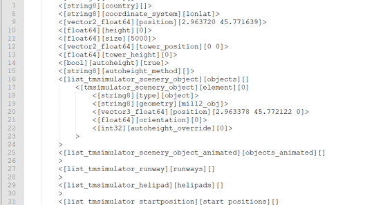
    1. First, I suspect you might have an issue with your TSC format? It looks a bit unorganized with different spacing etc. Meaning that Aerofly might have trouble reading the TSC.

    Try using a fresh separate TSC file only for your custom 3D Model. This will help you stay organized while learning at first.

    Here is new TSC you should use. Model TSC Test.zip

    Example of a clean and organized TSC:


    2. You mentioned that you have a TGI file along with BMP textures.

    This means you need to now convert them with the IPAC's content converter. This will generate the TMB and TTX files for the model.

    Example:

    Video Reference Timestamp

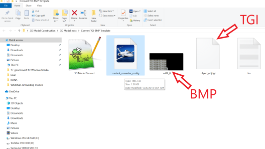
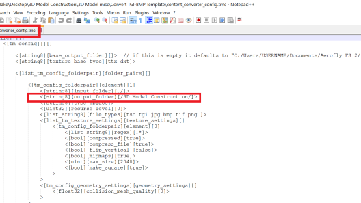
    3. Edit the Output Folder (To do this Right Click "content_converter_config" and rename desired location )

    Example: I named mine " 3D Model Construction "

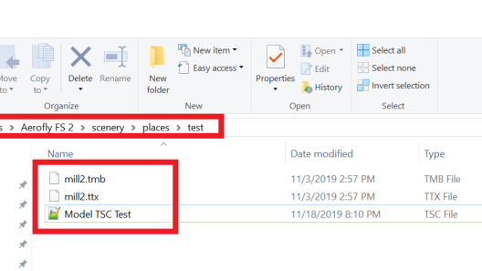
    After you have converted TGI and BMP. The files are now converted to a TMB and TTX format.

    5. Next locate converted TMB and TTX files in " 3D Model Construction " folder.

    Rename TMB file "object_obj" to desired model name.

    Example:

    Video Reference Timestamp

    6. Finally your new TSC. Model TSC Test.zip and TMB / TTX files should be moved and located to C:\Users\Jake\Documents\Aerofly FS 2\scenery\places

    Example:

    7. I pretty much just provided the exact same steps in the video. Hopefully the text and picture examples help.

    Again, I believe your issue might be in your TSC file that you provided me. Edit and try the TSC I provided.

    I suspect our language barrier might cause some issues. So hopefully Google Translate helps ;)

    If you are not successful. Please group and gather all your files and convert them into a ZIP file. This way I can better see the issue or problem.

    VR Flight Sim Guy is planning on doing a more in depth Reverb video. Numerous requests made and finally someone is making a video for Aerofly!

    External Content www.youtube.com
    Content embedded from external sources will not be displayed without your consent.
    Through the activation of external content, you agree that personal data may be transferred to third party platforms. We have provided more information on this in our privacy policy.

    This is most people's problem. Try to Compress all three images to one main image. Then you will have no problems. Example: When reducing/minimizing drawcalls choose texture size of 4096x4096 or reduce size of each image to perhaps 512x512. Not at computer but I think you get the idea of what I mean in MCX. Feel free to send a zip of your Dae file and textures and I can show you. Good luck