
ok gents;
I delete this post as we are going to test southern Scandinavia mesh block.
ok gents;
I delete this post as we are going to test southern Scandinavia mesh block.
 Display More
so here we go another day another mesh
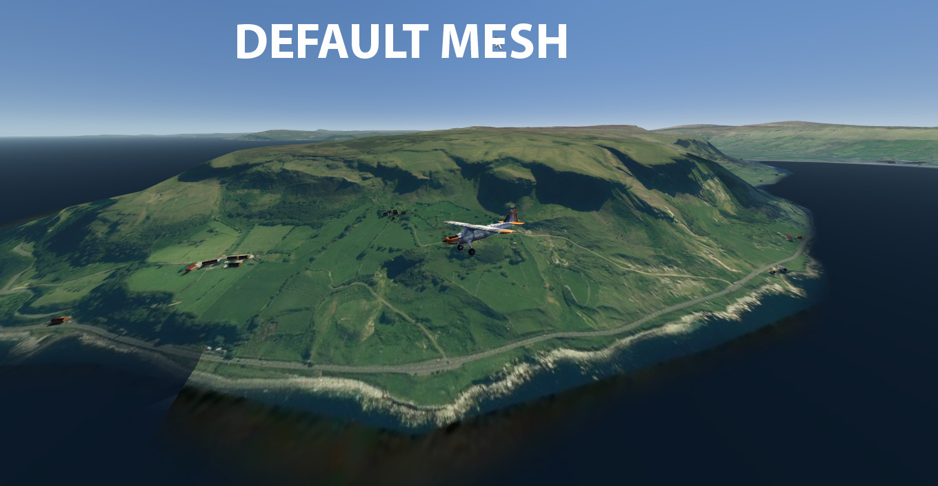
this is 10 m Ireland mesh;
now - Ireland is mostly a flat Island; this mesh show at its best around coastlines where the difference in elevation is noticeable; basically a flat pancake can not became a raised cake; but a low raised cake if cooked bit more can become a nice tall cake.
this mesh show at is best around shorelines cliffs; if you like fly around the coastline this can be useful.
The files will be available for download until Sun, 04 Aug 2019.
– elevation.zip

Thank you Ray for correcting the Tenerife cultivation.
Cheers,
Thomas
my pleasure

https://flight-sim.org/filebase/index…automatisation/
This will possibly help you.
good day;
Tenerife cultivation is now fixed and will be loaded as small download into servers very shortly.
data modification by ray; with the magical compilation skill by Michael; we put this right;
Ok Thomas;
I will have a look at that
compilation on multiple toc failed few times; will try again; but each go is a 6 hours shot
ray

https://flight-sim.org/filebase/
On the right side: "Donation"
absolutely
@flightextreme
If he/she chose an area already covered by photo textures to improve it is ok But this way? Same with the Mesh-Addons from Taburet![]() But this is just my opinion.
But this is just my opinion.
yes of course you have a point but there is no orthophotos in eu that are free to use other than few countries; beside that even if a whole country is done at nice resolution where is going to be hosted ?
nobody will want host either 20 or 90 gb of data as free ride or for 10 euro a piece distribution; let alone pay six digits for images copyrights ??
my only solution if want to continue do mesh and not having deleted from server is to put it on simmarket for a modest fee and for those who want it; after all pay 10 or 12 eur to have the files hosted and always available whenever needed is not too bad and simmarket is very very good on that.

Ray, i hope you have not set the missing part of Scandinavia on hold?
Since there is no mesh in AFS2 above 60 deg, a mesh from you would be much wanted. Pay or free
No hurry, i just hope you can do it
Raymond
Hi Raymond;
yes I will complete Scandinavia; and it carry on to be free
by the end of next week should be done.
ray

@ abbiati50
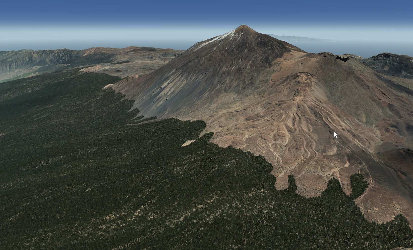
Ray, that looks great!
Are the screenshots from the Pyrenees?
Jakob
no Jakob
Himalayas
I am working on a complete 10 m coverage for whole Nepal and Bhutan
thanks Lucky1960 - glad it keep you up in the air and enjoy ! We are going to keep it that way; I promise you; we are going to see some great terrains !
and with that said; I am now posting the 19 m terrain for whole Spain I am working on it; to compare with 30 m srtm base test done above; look in the areas circled in yellow; the further resolution of 10 m add a new features missed by the 30 m srtm dem; more specifically look at that small plateau completely missed on the 30 m res mesh even although it was compiled and pushed all the way to level 10; as it is not a native resolution of 20 m features were missing; different story with a native 20 m data; this is very important for a simulator based on orthoimages to make it look at its best.
and now to end the 19 m in action; I always loved to fly over the Pyrenees ! fantastic place !!

Hello Abbiati,
I'm surprised because from what we've seen the default mesh in AFS2 is level 7 so with a resolution which cannot be more than ~150 meters / pixel (cf. the Vogel69's post here).
And over the Southern Alps I can see a big difference with my mesh based on tiles from J. de Ferranti (embeded SRTM 30m).
But on your screenshot it's not really the case, the default mesh looks great
good point; but there is a catch here;
the proof is in the pudding
the base mesh test I have done use the srtm 1 arc sec (30 m) compiled at level 10;
the key in mesh is the source data; if you compile srtm 1 at level 7; the result will not be much different than compiling at level 10; yes you will get less curved terrains but the difference is there on the images I have posted; is not major; we only gain a few levels of details but high res mesh is on another planet.
I am not completely sure what ipac have done but from what I see; ipac used to do default world at level 7 as Vogel69 described already (note default mesh end at N60 as srtm do) using srtm 1 arc sec data
And over the Southern Alps I can see a big difference with my mesh based on tiles from J. de Ferranti (embeded SRTM 30m).
de Ferranti data at 1 sec are only of limited coverage; for Europe I can make nice 19 m meshes (always pending end results tests) packages; similar as the Italy I done. We have data coverage for most of it; and with time we will get it all covered at high res than srtm can do.
good day
I will complete Scandinavia and post the link when done;
right now I am working to do Whole of Eu - in 4 blocks up to North 60 - eastern border will be around Estonia; down all the way to east Crete -
I will send this 4 blocks to simmarket; one by one as soon are done for those who want them; they are done from srtm data 1 arc sec;
this will provide an acceptable base mesh of extended coverage; and files will be always there available for those who want them.
always pending of successful data compilation
and here an image of what kind of mesh to expect
ok
today run lots of tests; and as make comparison between default mesh and a new base mesh;
default mesh over eu is not really far away of 30 m resolution; it is not bad in my opinion; I also check out west coast of us and it took me at 10 m res;
having said that compiling srtm 30 m datas; give some advantages (although geoconverter is very nervous using srtm data) ; the advantages are not a massive differencet but in the particulars; I post a comparison image;
in my opinion the new base will get even a bigger advantage when twinned with photorealistic as those extra elevation features will surely create a further 3d effect.
and here another test new base with photo and photo with default mesh
taking in consideration; that over existing default mesh areas (other than usa 10 m ) look like default aerofly mesh is lev 9 - at 38 m is not worth replace with another base mesh only just more detailed.
time will be better spent to concentrate to further higher resolution meshes coverages; and also work on areas above N60 where mesh is not there.
I can complete Scandinavia just need few days; right now fighting with content converter ![]()
![]()

THANK YOU so much Ray that's absolutely fantastic spending your time on this project. I will carry on making the photo scenery and sharing on flight-sim.org
Cheers, Michael.
good to be useful
feel free to upload the mesh into the org if you like; for others to download in the future.
ray
you welcome Jakob
I have completed Finland that also include a chunk of artic Norway ;
where the addon mesh meet with default mesh; you will see a gap as default terrain is flat and sunk below sea level.
Coverage map
abbiati50 Thank you for the mesh. Downloading it as I type. Uploading large files is a big problem for me also.
I have made photo scenery of all of Italy its 93 GBS!!!!!!!!!!!!!!!!!!!!!!!!!!
Looking for a good mesh to go with my Finland scenery shared on flight-sim.org?
phewww 93 gb - should look good with the mesh; post some images when you can; I am curious to see it
well after you chewed all those data to make Finland and Italy; I am making a Finland mesh for you - original
data 1 sec - 30 m (Finland is mostly flat will work ok) courtesy of J De Ferranti of viewfinderpanoramas.org
he is a flight simmers friend !
I am working on it; if all goes well will load later or tomorrow.
ray
good day all;
today was large scale mesh compilation day; as some of you already know the area of test was the whole of Italy.
It look like all went well; so I have uploaded the files on the link below to download for those who are interested.
This file need to find a permanent home; there is no restriction attached to it; please if you can host it somewhere please do so
the download link is only valid for a week; but if you find a permanent residence to the file feel free to post the link.
Few words about the mesh; inside the Italian border native model resolution is 20 m; I have to create a buffer zone
outside the Italian border to square the model for compilation using srtm data; bit less detailed but still an acceptable
standard.
I also include a 15 m test area textures on the Mont Blanc for those who actually want to see how the mesh work.
coverage coordinates; coverage map included in zip.
all done and packing- need to take some new images as the terrain is changed
and for those who love this particular airport it has been given lots of love and It is open for business
 Display More
Hi Ray:
Thanks for the recent pics. They look gorgeous!. Eagerly waiting for your update.
Your appreciations are correct. Aerofly has big strong points or advantages, like graphics engine, terrain engine (as you said), very fluid with normal FPS well above 100 and most importantly, being those FPS constant (so, no stuttering). Also, it's very simple to setup, use and maintain, and very reliable. It's also important to mention that its VR capabilities are top notch in the business.
The main issue with Aerofly has been in my opinion, the lack of complimentary features like real weather including winds and rain effects, more complex aircraft systems, ATC communications, AI traffic, flight planning, to really be a true and complete flight simulator. So far, if you look at these forums, almost everybody is just talking about the trilogy photo-scenery, geo-conversion & cultivation, so mainly talking about scenery making and viewing, and that's simply not enough (to me!). Even at this point we don't really know if some or just part of the above mentioned features will ever be implemented, since so far IPACS has been reluctant to release a roadmap for AFS2, and all progress, measured by the addition of those features has been extremely slow.
We also need that more developers jump into the game to produce add-on scenery, aircraft, etc., to complement the sim, as has always been the case with FSX and now P3D and X-Plane. So, I'm really excited by the fact that you like AFS2 and expect you'll be able to stay in and produce more detailed scenery in the future.
Of course, I can be wrong, but this is my true feeling!.
Cheers, Ed
Maybe with time more features will be implemented into the sim; by ipacs or third party developers
aerofly base is excellent; and if keep going this path the simulator is going to be a winner.