Glider Map / Nav App (just playing)

  • With the missing map in VR I thought I would look into third party options. And the only really way is using OVRDrop and FsWidgets, but FsWidgets isn't really aimed at gliders.

    So being a developer I thought I would have a play, turned our a lot easier than I thought to get something very basic working. Not tried it in any VR overlay yet (OVRDrop/Daily VR).

    External Content www.youtube.com
    Content embedded from external sources will not be displayed without your consent.
    Through the activation of external content, you agree that personal data may be transferred to third party platforms. We have provided more information on this in our privacy policy.

    Andy


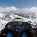
    Just showing a little bit of progress today.

    Added some basic flight information and the beginnings of a waypoint system. Current its just showing the heading back to 1 waypoint set at the airfield, the distance to that waypoint is also shown.

    External Content www.youtube.com
    Content embedded from external sources will not be displayed without your consent.
    Through the activation of external content, you agree that personal data may be transferred to third party platforms. We have provided more information on this in our privacy policy.

    Andy

  • Had some success using dailyvr tonight, but after some thought and dailyvr not quite fitting what I wanted I have decided to write my own VR overlay app specifically for glider maps. Don’t see the point of having two apps/overheads when i can just do one - and it means I can specifically develop it to suit Aerofly glider cockpit.

    Will update as I go.

    Andy

  • Ok so, as mentioned above, I decided not to use one of the already developed overlay apps (OVRDROP, DailyVR ETC) to bring in my GliderNav into FS2 because:

    A) They cost more

    B) They are not really designed for this so very clunky with bigger overheads on performance

    C) I can have full control over how I want it look & work.

    So I scrapped my original windows based GliderNav app and spent a bit of time today (not as much as i wanted) working on my own VR overlay system and only just had time to capture something before I had to go out.

    But this shows at least it working, this is my own overlay showing a full moving map (streamed in real-time). The video shows some jitter/movement between the map and the cockpit but this DOES NOT happen in the sim, so must be something of the SteamVR window I used to record it.

    So now to get to work on the map itself and the size/positioning within the cockpit.

    And sorry for the "shaking", thats me putting my headset on and then off.

    External Content www.youtube.com
    Content embedded from external sources will not be displayed without your consent.
    Through the activation of external content, you agree that personal data may be transferred to third party platforms. We have provided more information on this in our privacy policy.

    Edited once, last by gonzo84 (September 13, 2019 at 8:14 PM).

  • I like. If gliding all together would be better in AFS2 I'd play a lot less condor. AFS2 is such a more pleasant environment to be in.

    I agree and my goal, although obviously I am limited to what can be done. But if I can at least get a decent map / nav system working then it will help to improve.

    I just wish either Aerofly had condors wind, thermal system and multiplayer or condor got Aerofly graphics and VR performance.

    🙄

  • Small progress update.

    Done a lot of work on the actual VR overlay code itself and a then just made the map actually look like a device.

    The video below shows some jerkiness/elastication but again in VR this does not occor so its just from the recording.

    The video also seems to show the Nav device bigger than what it looks like in VR, in VR I have it so it looks something between a phone and a tablet.

    Next few days I will be adding actual Tasks/point to the map.

    External Content www.youtube.com
    Content embedded from external sources will not be displayed without your consent.
    Through the activation of external content, you agree that personal data may be transferred to third party platforms. We have provided more information on this in our privacy policy.

  • Hello gonzo84,

    Can you also provide us with your Navkarte for other aircraft within the simulation? I would be so happy finally to have a navigation map in VR available in all aircraft.

    Whether this is possible and with how much work I do not know, because I am in this respect only a (lucky) user of such freeware and have no experience of programming.

    So do not be angry is just a question and not a requirement!

    Thank you for the work and idea and I'm looking forward to your result!

    Good luck

    Werner

    Hallo gonzo84,

    Kannst Du uns Deine Navkarte auch für andere Flugzeuge innerhalb der Simulation zur Verfügung stellen? Ich wäre so glücklich endlich eine Navigationskarte in VR auch in allen Luftfahrzeugen zur Verfügung zu haben.

    Ob dies möglich ist und mit wieviel Arbeit weiss ich nicht, da ich in dieser Hinsicht nur ein (glücklicher) Benützer solcher Freeware bin und keine Erfahrung von programmieren habe.

    Also nicht böse sein ist nur eine Frage und keinesfalls eine Forderung!

    Danke Dir für die Arbeit und Idee und ich freue mich schon sehr auf Dein Ergebnis!

    Froher Gruss

    Werner

    Froher Gruss :)

    Para

  • Hello gonzo84,

    Can you also provide us with your Navkarte for other aircraft within the simulation? I would be so happy finally to have a navigation map in VR available in all aircraft.

    Add me here. At present, I mostly fly the Turbo Arrow under VR which, at least, comes with a usable GPS (contrary to the C172 GPS with its very limited functionality and poor readability).

    If I could integrate your Moving Map into, say, the C172 that would be flightsim heaven. I would even be willing to pay for this.

    Kind regards, Michael

    Intel i7-6700K 4.0 GHz / Asus MAXIMUS VIII RANGER / Kingston 32 GB DDR4 / Samsung SSD M.2 500 GB + Samsung SSD 1 TB + Intel SSD 500 GB (AeroflyFS2) + WD HD 6 TB / EVGA GTX 1080Ti 11 GB / LG 34UM95 3440 x 1440 / HP Reverb / Win 10/64

  • Hi Michael, I actually never really thought about using it in other aircraft's as I thought i was only the glider suffering with no nav, but as its stands as this is an overlay it will work in any aircraft.

    If its better than what is already in the C172 I wouldn't know as i dont fly the C172, however being the developer I can of course implement any features into it.

    thanks

    Andy

  • Hi Michael, I actually never really thought about using it in other aircraft's as I thought i was only the glider suffering with no nav, but as its stands as this is an overlay it will work in any aircraft.

    :) It's amazing, our addon developers are becoming better and better every day. Is it possible to give a bunch of "likes" here?

    One million thanks and best regards, Michael

    Intel i7-6700K 4.0 GHz / Asus MAXIMUS VIII RANGER / Kingston 32 GB DDR4 / Samsung SSD M.2 500 GB + Samsung SSD 1 TB + Intel SSD 500 GB (AeroflyFS2) + WD HD 6 TB / EVGA GTX 1080Ti 11 GB / LG 34UM95 3440 x 1440 / HP Reverb / Win 10/64

  • Michael, I am thinking the same thing. The timing might be just right for many of these nifty new features to come together, but, it looks like IPACS is not interested in any of them (based on the total lack of comments from Admin). But, I guess that leaves us avid users to heap praise on those new creative thinkers and to encourage more and more.

    I have been beta testing yet another "most asked for" product for the last couple of weeks and I have no doubts it will fall right in the middle of these discussions. Talk about immersion, we might finally be getting to a level where the VR flyers can actually see and participate in a flight plan.

    Every new day seems to bring something new, except from IPACS. hmmm.

  • Thank you for the comments. I like to think (hope) that IPACS might be working on wonderful features such as multiplayer or ATC etc.

    However, I do agree that there is a nice community of modders on here from what i can see in my short time which is great. I actually had no idea about sceneProc and Aerosceney at the time of buying so when I found those I really was over the moon.

    One thing I also developed which I really liked, was using "leapmotion" hands in Aerofly VR. If i get chance I will get a video going, it was more experimental than anything but the concept worked, however unfortunately "virtual interaction" with switches and knobs wouldnt be possible so it would require physical switches to actually touch and interact back with Aerofly to keep the immersion.

    And my last idea for gliding was multiplayer competition using a plugin but without the visual aspects of other gliders in view, just the actual "real-time" data. However, i then realised this wouldn't work because thermals and conditions wouldn't match. :(

    Andy

  • Andy,

    Keep thinking. 8o I am interested in seeing if your visual map can support a picture in a picture type box that we can feed active data. It would be outstanding if we could get a flight plan overlay on the active map with a box on the same screen with some text data.

    This would be a whole new level of important data for the pilot, whatever the craft he/she may be flying.

    I guess I can make it do anything you want (within reason of course!!) but feeding in data wouldn't be an issue or fetching data from "somewhere" either offline or online also wouldn't be an issue.

    I assume by flight plan overlay you mean aeronautical charts?

    Another feature I have implemented is it records the flight data. I thought seeing as I am capturing and processing the flight data I might as well save it in a format which you can then see the flight path back in google maps ETC. - not sure if will be of any use to anyone else.

    Andy

    Edited once, last by gonzo84 (September 27, 2019 at 5:05 PM).

  • Great news about the box with a data feed. That is outstanding and exactly what we need for VR flying for some very basic data flow. Nothing more than which key to press for further instructions to for user requests. We have the data flow figured out, but was yet to solve the how to display the data box while flying VR.

    As for the flight plan, it would be totally over the top if we could somehow get something like the fsWidgets displayed flight plan to be present on your popup nav map. Currently I use a second window with fsWidgets maps showing my flight plan with a moving icon for present position along with some data like speed, altitude, heading, etc showing at the edge of the map display. Problem is, this is not available in VR.

    fsWidgets offers dozens of maps/charts that can be selected with a click. Standard flight plans can be imported and displayed. Currently the progress is only available by duplicating the flight plan using the NAV screen of AFS2 but, it works fine, just duplicate work for now.

  • Ahh I see ok.

    So the current version that I have ready now, lets you import a flight path (or as I called them, tasks).

    The flight path / task I create using another "in-broswer" web app which I've have developed, however if fswidgets or someother software allows you to export the flight path - I can then make it so you can import that into my Nav Device and it show over the map like it already does.

    Basically - a list of way points (long, lat) and anything else such as alt?

    Andy

  • F18 Kneepad (not really GPS based map, but hey).

    More importantly what you've created is basically a functional MPCD (The central lower screen in the F18).

    The real one has multiple displays (not the point here) and functions (with buttons) but the current FS2 one is only a green moving elevation map.

    Your code, or some evolution of it, could maybe be integrated to create that display with more reality and functionality. I don't know how to do any of it (I wish I did), but the thought is interesting. Maybe Jan will be interested.

  • Alternatively could the VR window display fswidget maps, and buttons? Wouldn't that be the answer to all?

    Maybe contact the makers of fswidget and sell them the code?

    see pm.

  • So I have done another little video showing its current development state.

    Although, it is very difficult to record in VR and show it in its entirety. So again this video has some "jerkiness" to it but its simply because there is a lot going off whilst recording I guess, and this is only the left eye so doesn't quite record what im seeing!! So I will try to release a Beta version this weekend for anyone to try, including the "navigation / flight path creator".

    Anyway, the red circles are waypoints (starting at my local glider airfield) and the black line is to the next way point (in this case it is a triangle back to the airfield). The blue line shows the current direction to the airfield.

    External Content www.youtube.com
    Content embedded from external sources will not be displayed without your consent.
    Through the activation of external content, you agree that personal data may be transferred to third party platforms. We have provided more information on this in our privacy policy.